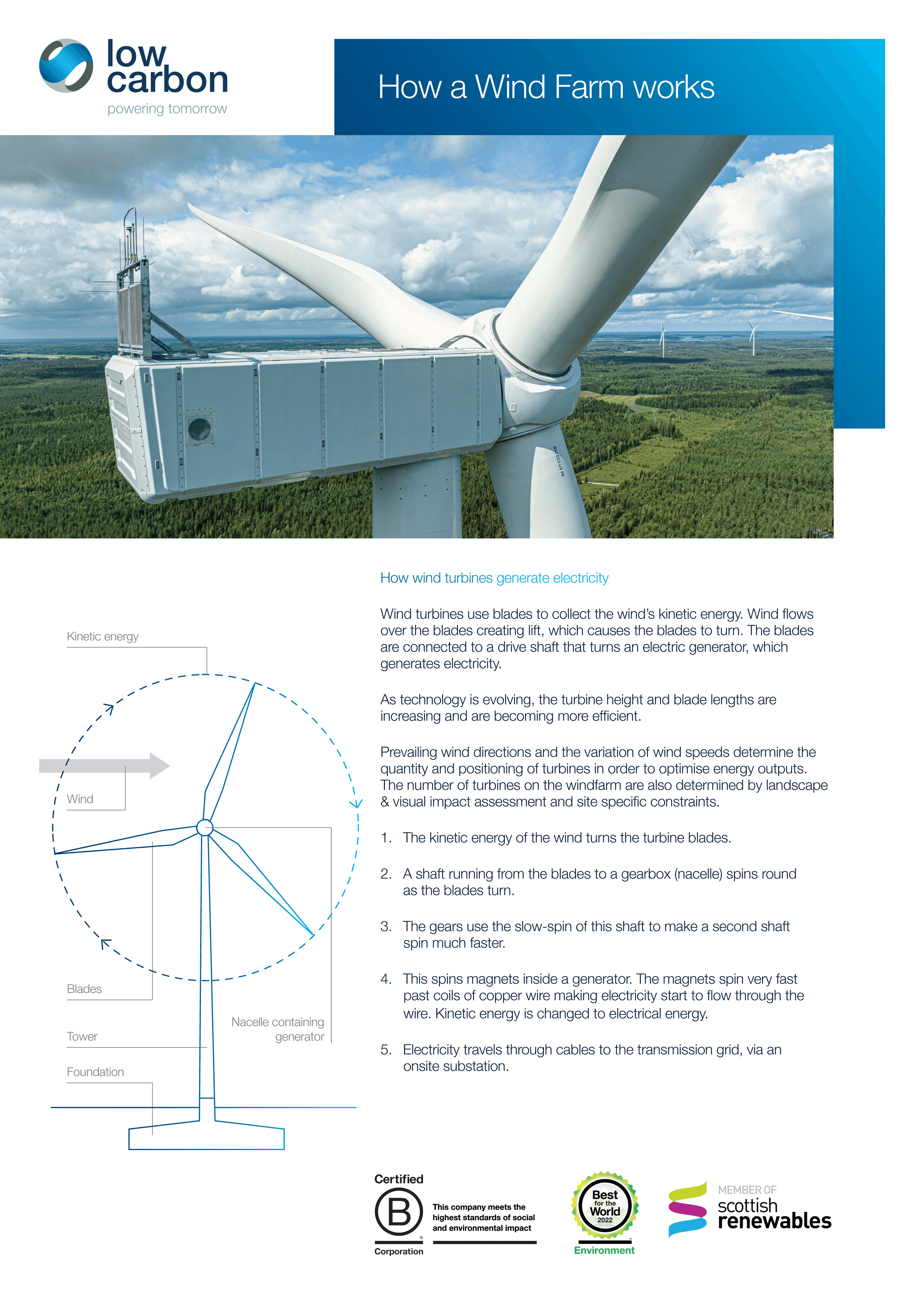
High Brenfield Wind Farm
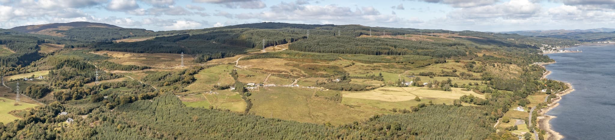
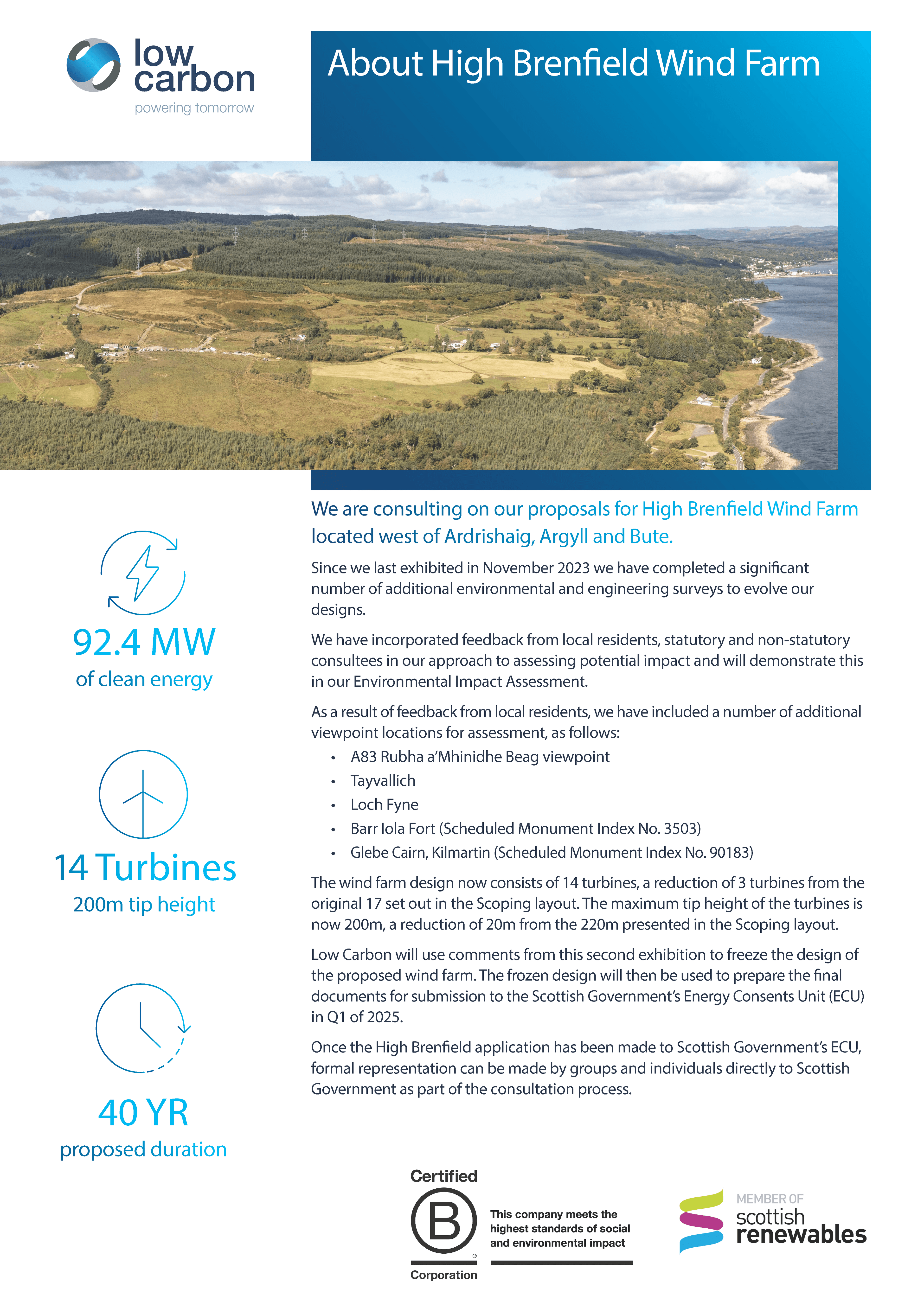
Low Carbon is proposing a new wind farm development, known as High Brenfield Wind Farm, located on land approximately 2km south-west of Ardrishaig, near Lochgilphead and entirely within the Argyll & Bute Local Authority area.
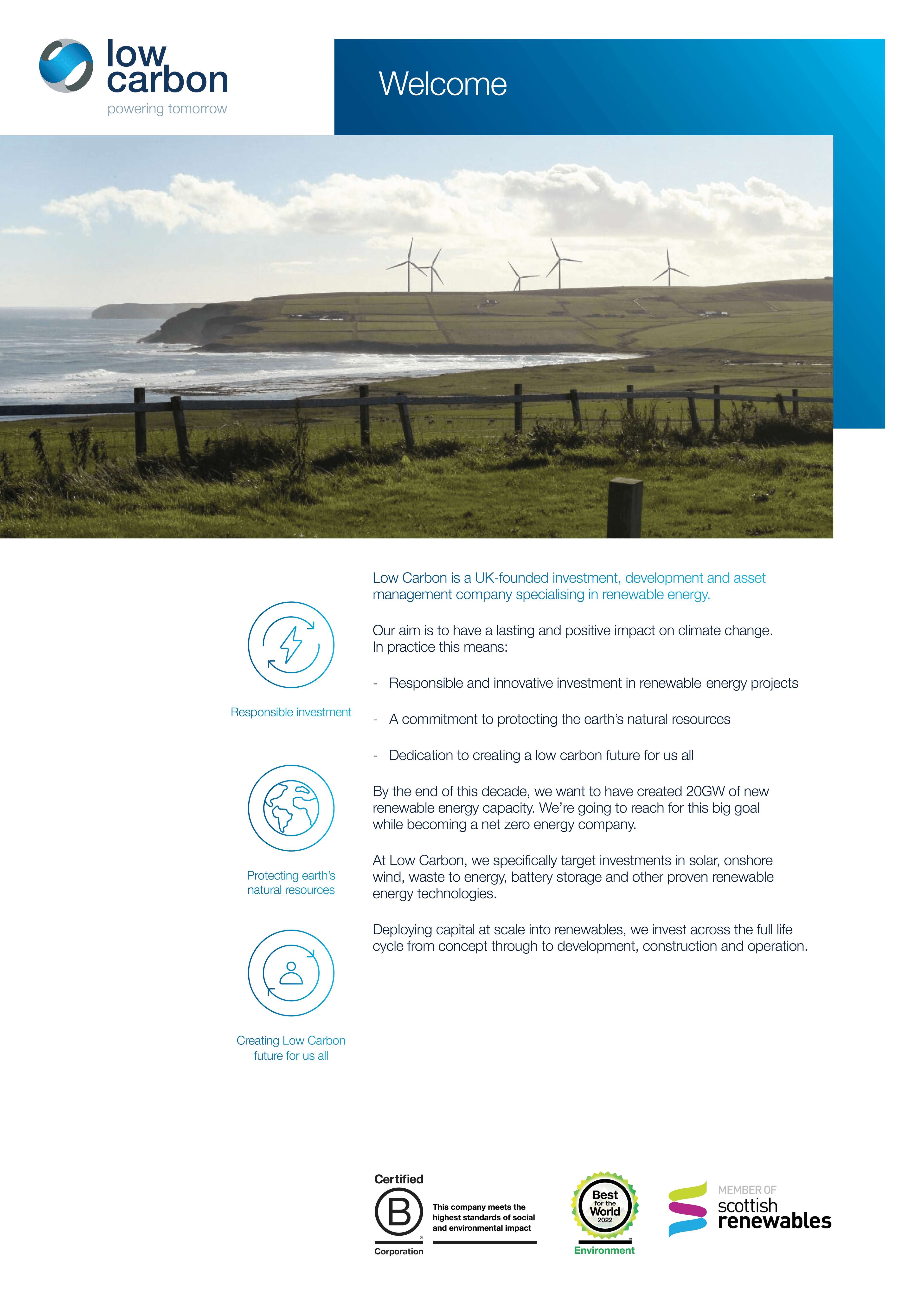
Welcome to
High Brenfield Wind Farm

Angus Thomson
Project Development Manager
Low Carbon is proposing a new wind farm development, known as High Brenfield Wind Farm, located on land approximately 2km south-west of Ardrishaig, near Lochgilphead and entirely within the Argyll & Bute Local Authority area.
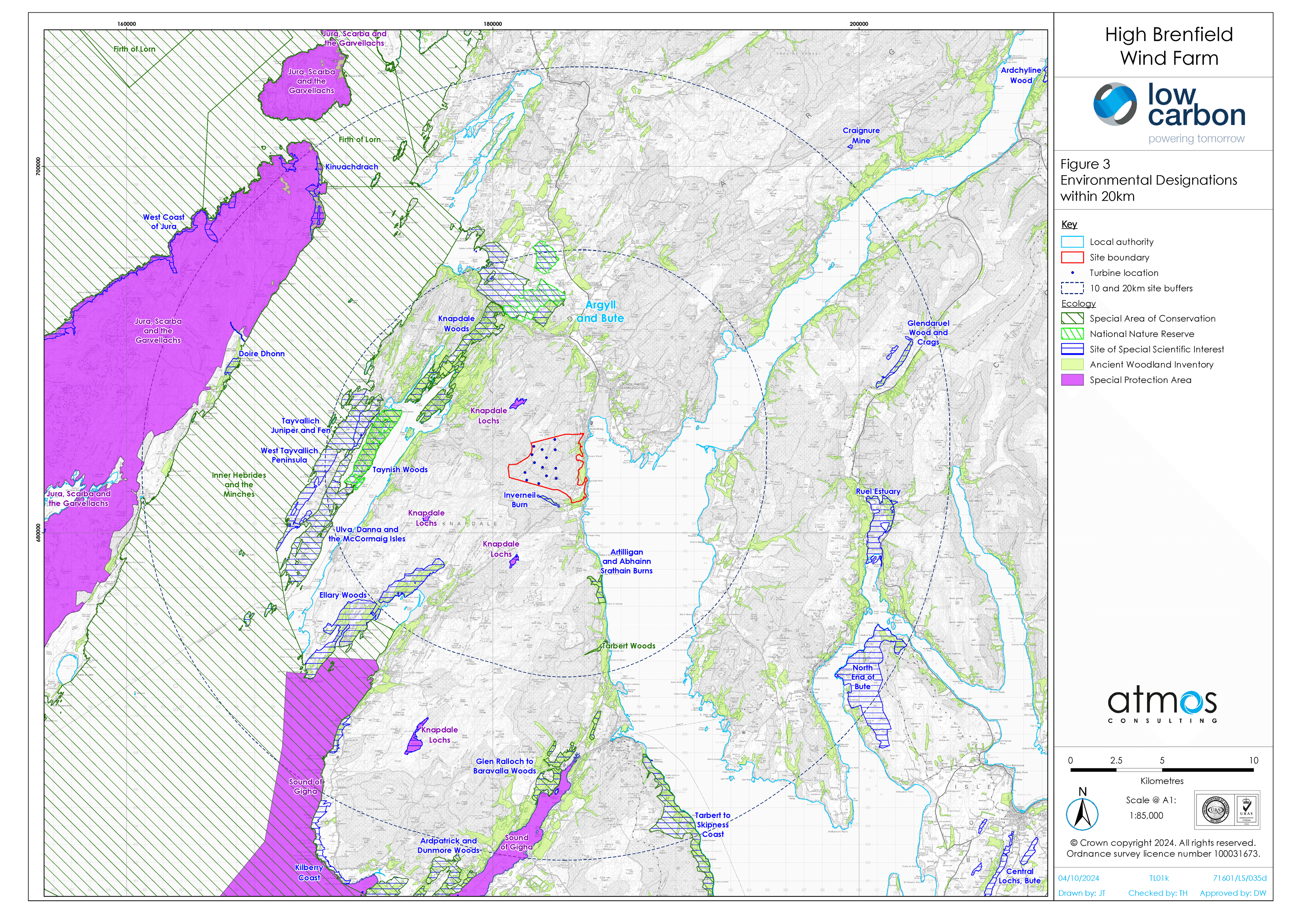
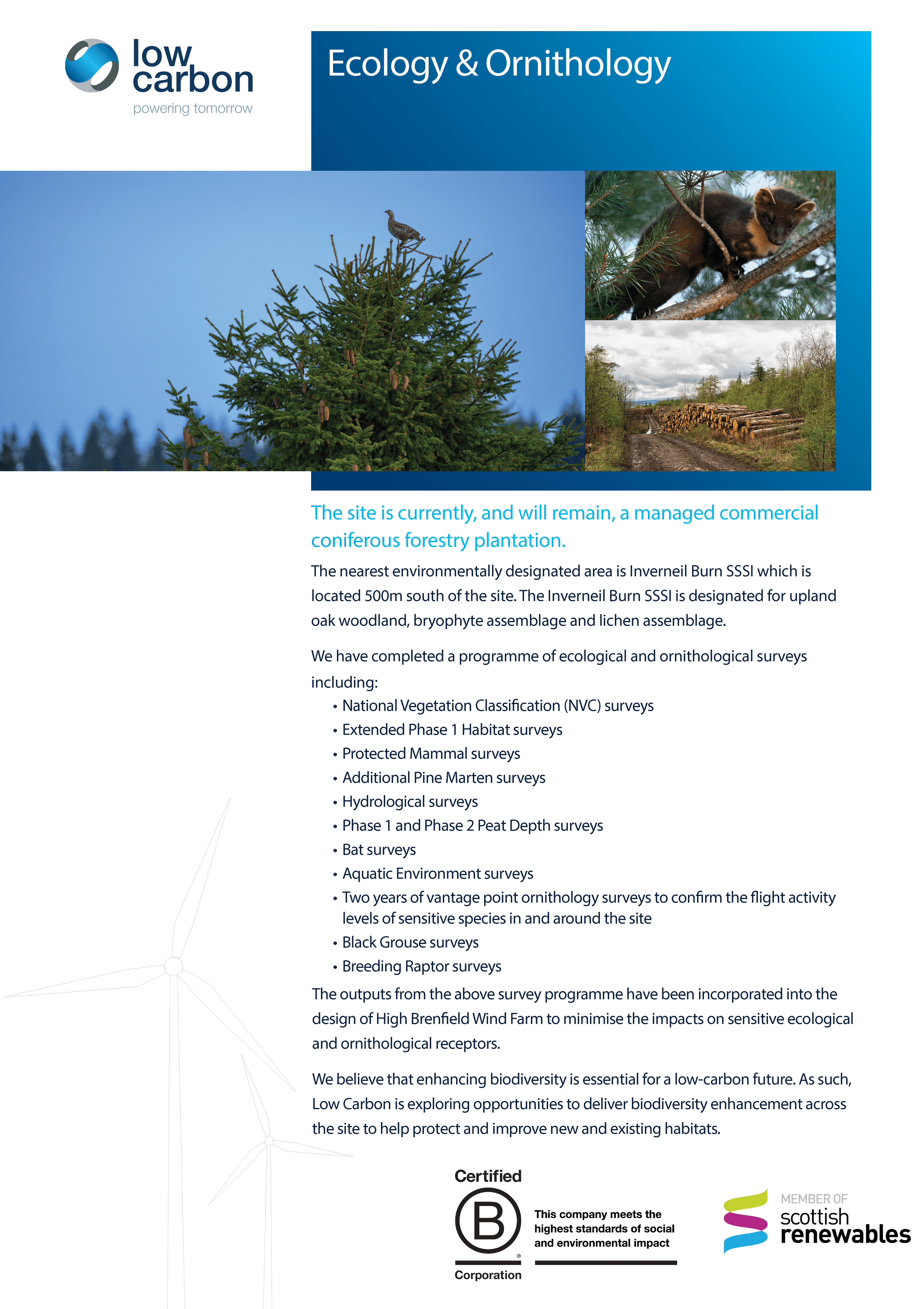
The Proposed Development site is free from national designation and currently operates as a commercial forestry plantation of predominantly non-native species.
The recently constructed Inverary to Crossaig 275 kV overhead electricity transmission line crosses the eastern part of the development site from north to south.
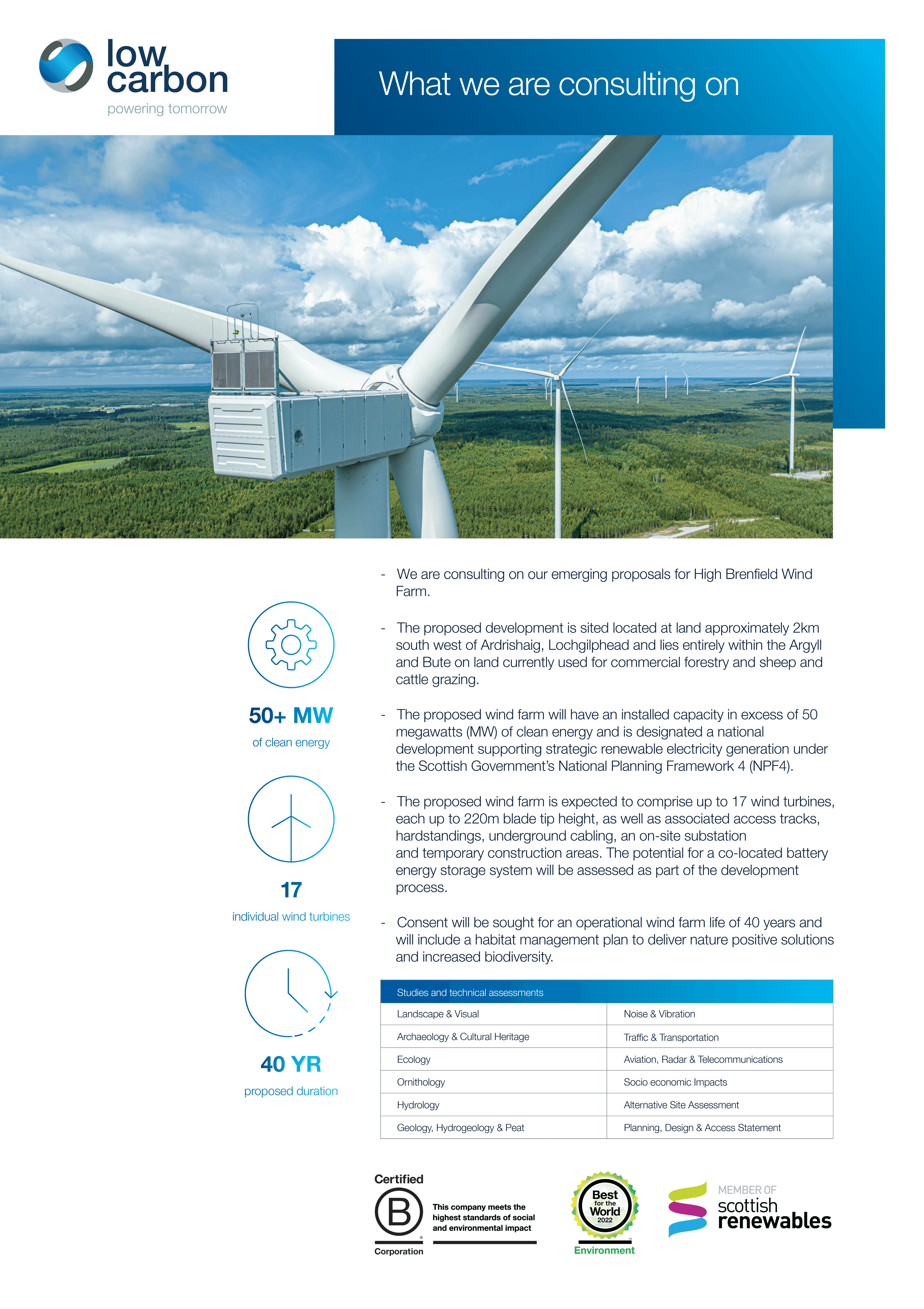
The Proposed Development will have a maximum generating capacity of greater than 50 megawatts (MW).
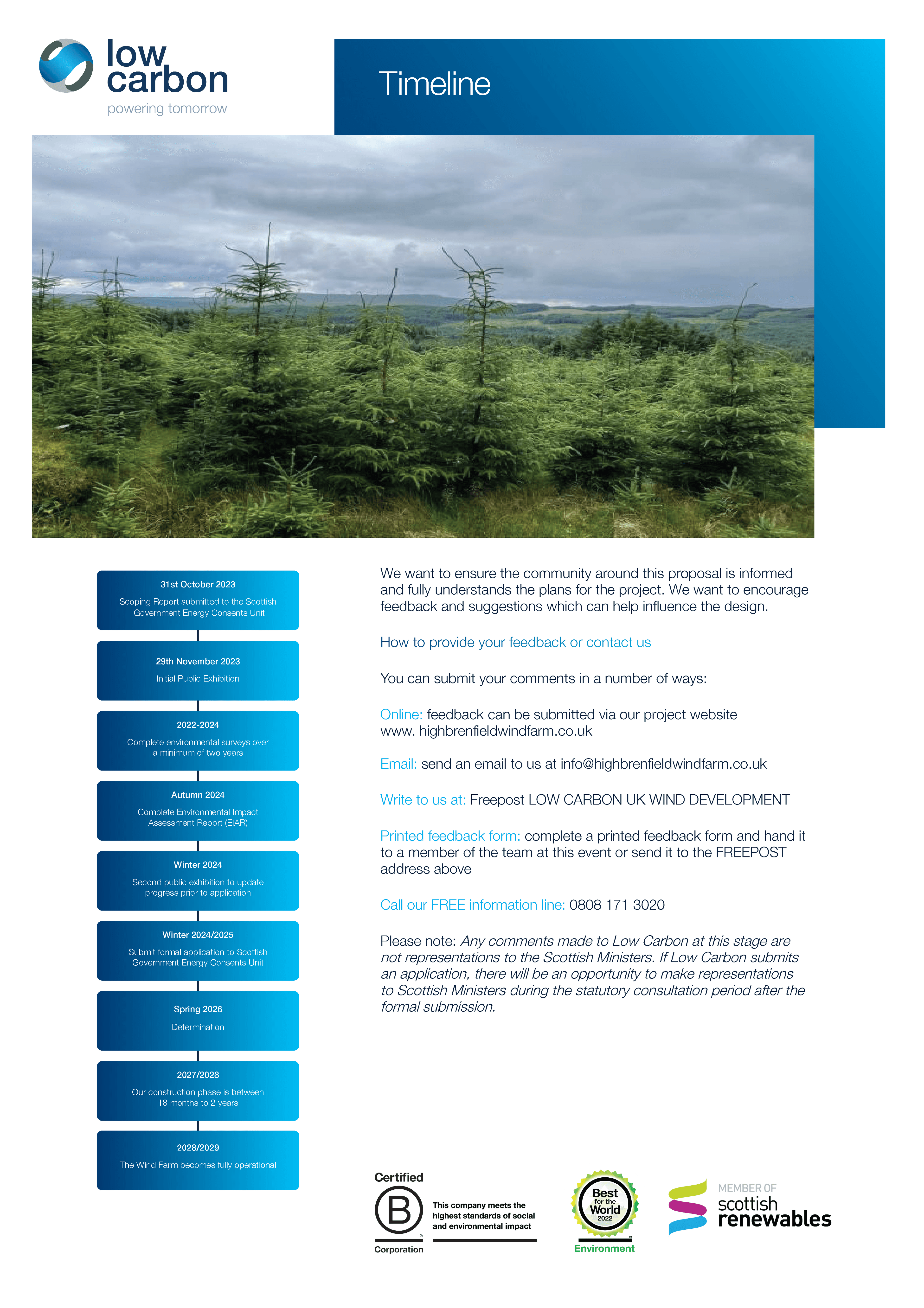
A Section 36 application was made to the Scottish Government’s Energy Consents Unit in June 2025.
The Section 36 application can be viewed here:
Application Documents
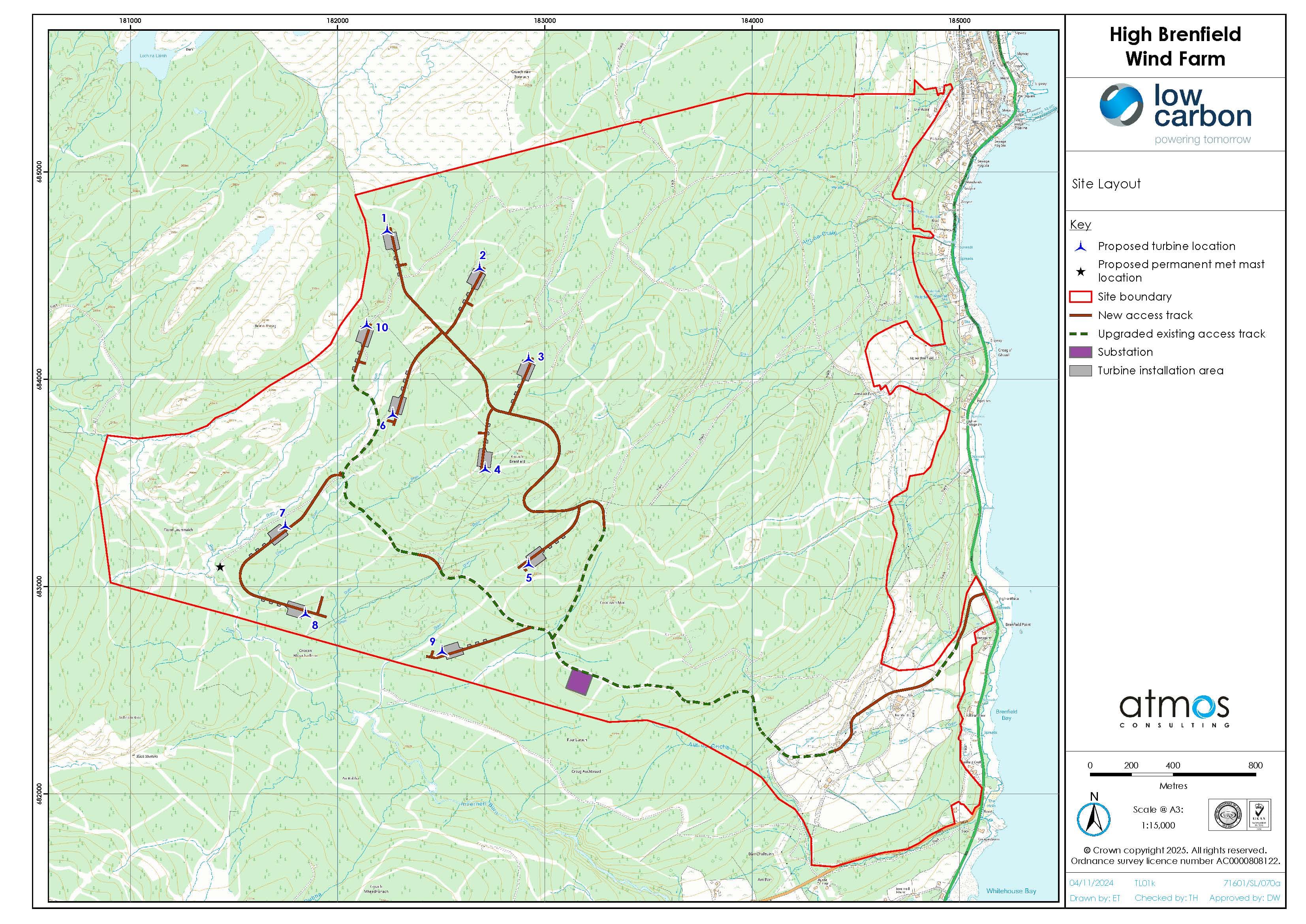
In June 2025 Low Carbon submitted a Section 36 Application and Environmental Impact Assessment Report to the Scottish Government’s Energy Consents Unit (ECU) for High Brenfield Wind Farm. The Proposed Development consists of up to 10 turbines with a maximum tip height of 200m, a permanent met mast up to 125m and associated infrastructure. The full suite of application documents can be viewed using the links below.
If you would like a download link for the full application emailed directly to you, please contact info@highbrenfieldwindfarm.co.uk.
All documents can also be viewed and downloaded via the Scottish Government Energy Consents Unit.
Public Notice
Volume 1 - Non-Technical Summary
Volume 2 - Environmental Impact Assessment Chapters
- Volume 2 - Chapter 1 Introduction
- Volume 2 - Chapter 2 EIA Approach and Methodology
- Volume 2 - Chapter 3 Description of Development
- Volume 2 - Chapter 4 Planning and Energy Policy
- Volume 2 - Chapter 5 Landscape and Visual Impact Assessment
- Volume 2 - Chapter 6 Ecology
- Volume 2 - Chapter 7 Ornithology
- Volume 2 - Chapter 8 Hydrology, Hydrogeology and Geology (including Peat)
- Volume 2 - Chapter 9 Transport and Access
- Volume 2 - Chapter 10 Cultural Heritage
- Volume 2 - Chapter 11 Noise
- Volume 2 - Chapter 12 Forestry
- Volume 2 - Chapter 13 Socioeconomics, Tourism and Recreation
- Volume 2 - Chapter 14 Climate Change and Carbon Balance
- Volume 2 - Chapter 15 Other Considerations
- Volume 2 - Chapter 16 Schedule of Mitigation
- Volume 2 - Chapter 17 Summary of Residual Effects
Volume 3 - Technical Appendices
- Volume 3 - Technical Appendix 2-1 Scoping Opinion
- Volume 3 - Technical Appendix 2-2 Gatecheck 1 Report
- Volume 3 - Technical Appendix 5-1 Assessment Criteria
- Volume 3 - Technical Appendix 5-2 Visualisation Information
- Volume 3 - Technical Appendix 5-3 Assessment of Night-time Lighting
- Volume 3 - Technical Appendix 5-4 Preliminary Assessment of Designated Sites and Landscape Character Types
- Volume 3 - Technical Appendix 5-5 Preliminary Assessment of Visual Receptors
- Volume 3 - Technical Appendix 5-6 Viewpoint Assessment
- Volume 3 - Technical Appendix 5-7 Residential Visual Amenity Assessment
- Volume 3 - Technical Appendix 5-8 Assessment of Effects on Special Landscape Qualities
- Volume 3 - Technical Appendix 5-9 Aviation Lighting Mitigation Analysis
- Volume 3 - Technical Appendix 6-1 Phase 1 Habitat and National Vegetation Classification Survey
- Volume 3 - Technical Appendix 6-2 Protected Species
- Volume 3 - Technical Appendix 6-3 Bats Surveys
- Volume 3 - Technical Appendix 6-4 Fish Habitat Survey
- Volume 3 - Technical Appendix 6-5 Habitat Management Plan
- Volume 3 - Technical Appendix 7-1 Ornithology
- Volume 3 - Technical Appendix 8-1 Watercourse Crossing Assessment
- Volume 3 - Technical Appendix 8-2 Peat Landslide Hazard Risk Assessment
- Volume 3 - Technical Appendix 8-3 Outline Peat Management Plan
- Volume 3 - Technical Appendix 8-4 Private Water Supply Risk Assessment
- Volume 3 - Technical Appendix 8-5 Drainage Impact Assessment
- Volume 3 - Technical Appendix 8-6 Borrow Pit Assessment
- Volume 3 - Technical Appendix 9-1 Abnormal Load Assessment
- Volume 3 - Technical Appendix 9-2 Access Junction Drawings
- Volume 3 - Technical Appendix 9-3 Road Safety Audit
- Volume 3 - Technical Appendix 9-4 outline Construction Traffic Management Plan
- Volume 3 - Technical Appendix 10-1 Setting Assessment
- Volume 3 - Technical Appendix 10-2 Gazetteer
- Volume 3 - Technical Appendix 10-3 Cumulative Assessment
- Volume 3 - Technical Appendix 11-1 Baseline Measurements Report
- Volume 3 - Technical Appendix 11-2 Noise Prediction Methodology
- Volume 3 - Chapter 12 Technical Appendix Photographic Records
- Volume 3 - Technical Appendix 14-1 Carbon Calculator Inputs
- Volume 3 - Technical Appendix 15-1 Reduced Aviation Lighting Scheme Approval
- Volume 3 - Technical Appendix 15-2 Joint Radio Company High Brenfield Exclusion Zones Report
- Volume 3 - Technical Appendix 16-1 Outline Construction Environmental Management Plan
Volume 4 - Figures
- Volume 4 - Figure 1-1 Site Location Plan
- Volume 4 - Figure 1-2 Site Layout
- Volume 4 - Figure 1-3 Site Context
- Volume 4 - Figure 1-4 Cumulative Sites to 15km
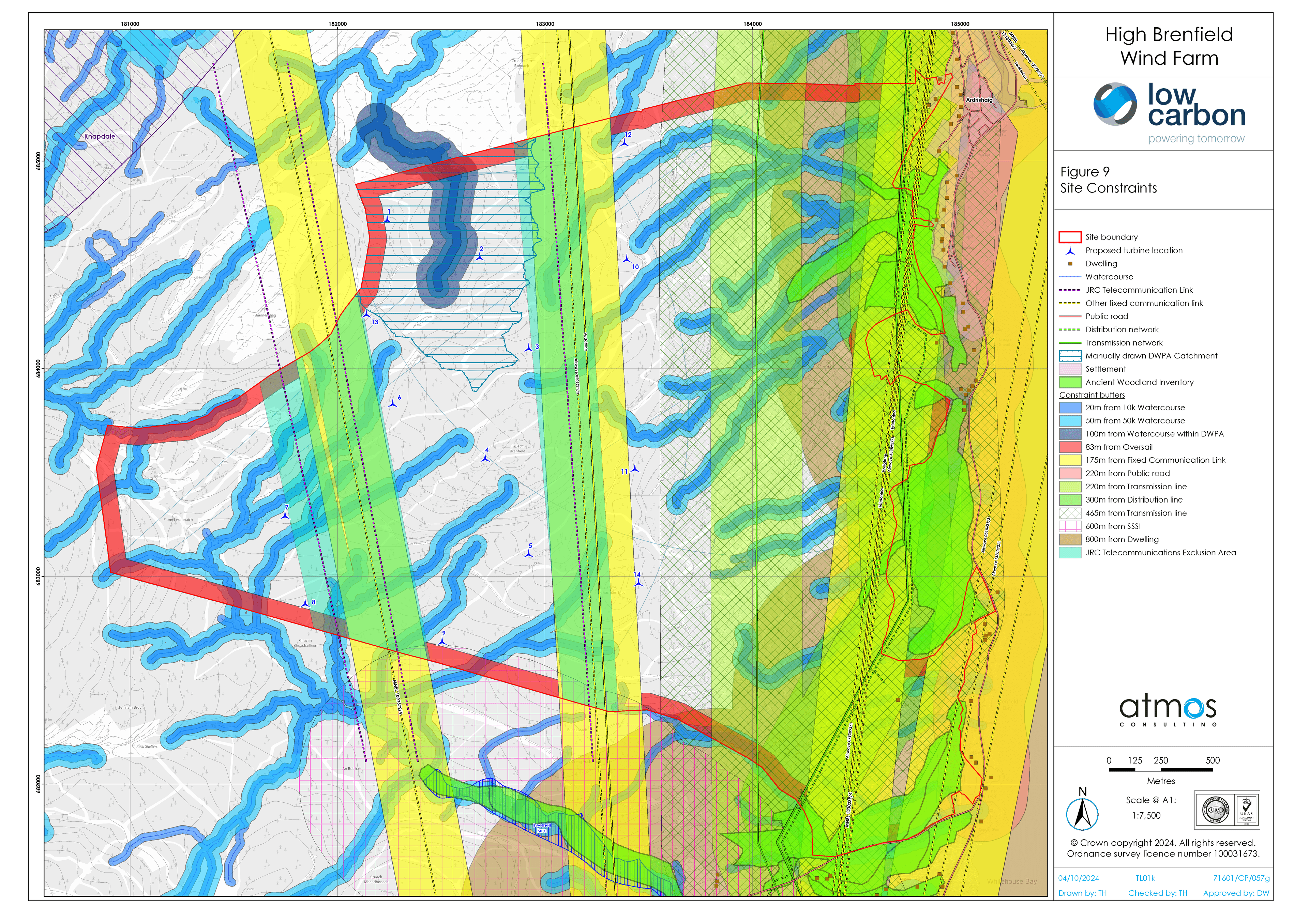
- Volume 4 - Figure 3-1 Site Layout
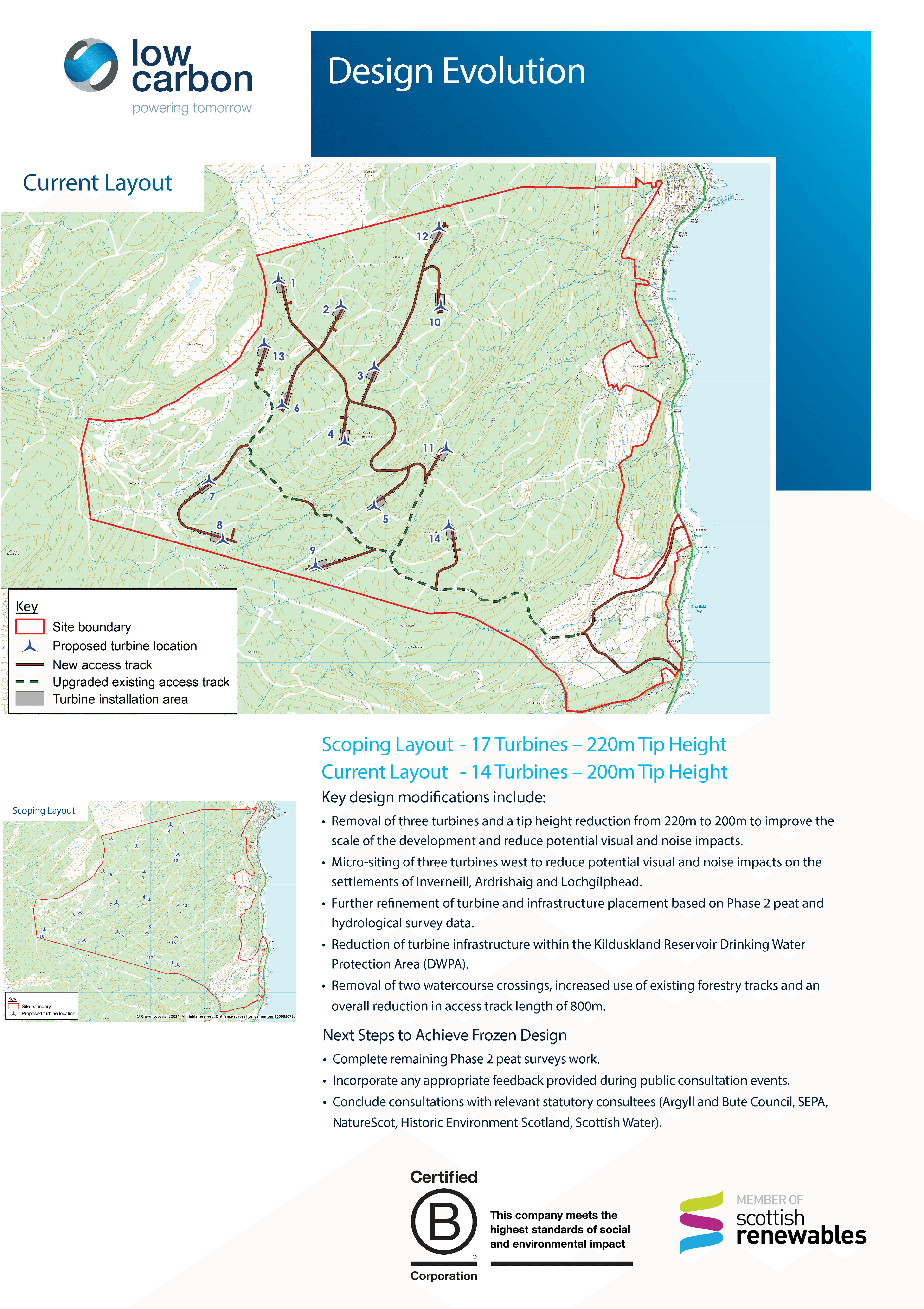
- Volume 4 - Figure 3-2 Design Evolution
- Volume 4 - Figure 3-3 Indicative turbine
- Volume 4 - Figure 3-4 Indicative turbine foundation
- Volume 4 - Figure 3-5 Indicative Turbine Hardstand
- Volume 4 - Figure 3-6 Indicative construction compound
- Volume 4 - Figure 3-7 Indicative access track and cable trench
- Volume 4 - Figure 3-8 Indicative Substation
- Volume 4 - Figure 3-9 Indicative Met Mast
- Volume 4 - Figure 3-10 Typical Drainage Details
- Volume 4 - Figure 3-11 - Typical Watercourse Crossing Details
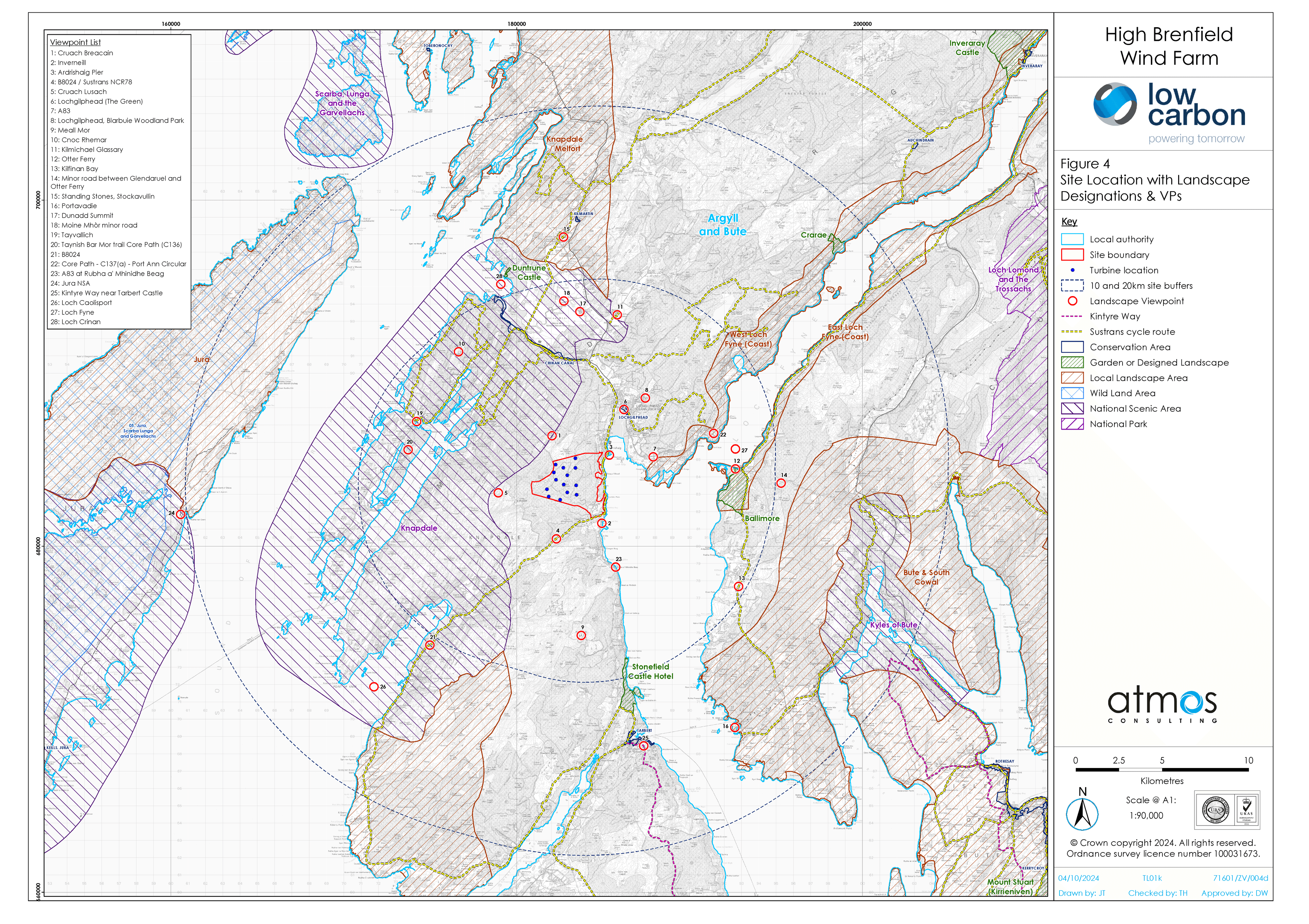
- Volume 4 - Figure 5-1 Site Location and Initial Landscape and Visual Impact Assessment Study Area 45km
- Volume 4 - Figure 5-2 Site Location and Detailed Landscape and Visual Impact Assessment Study Area 20km
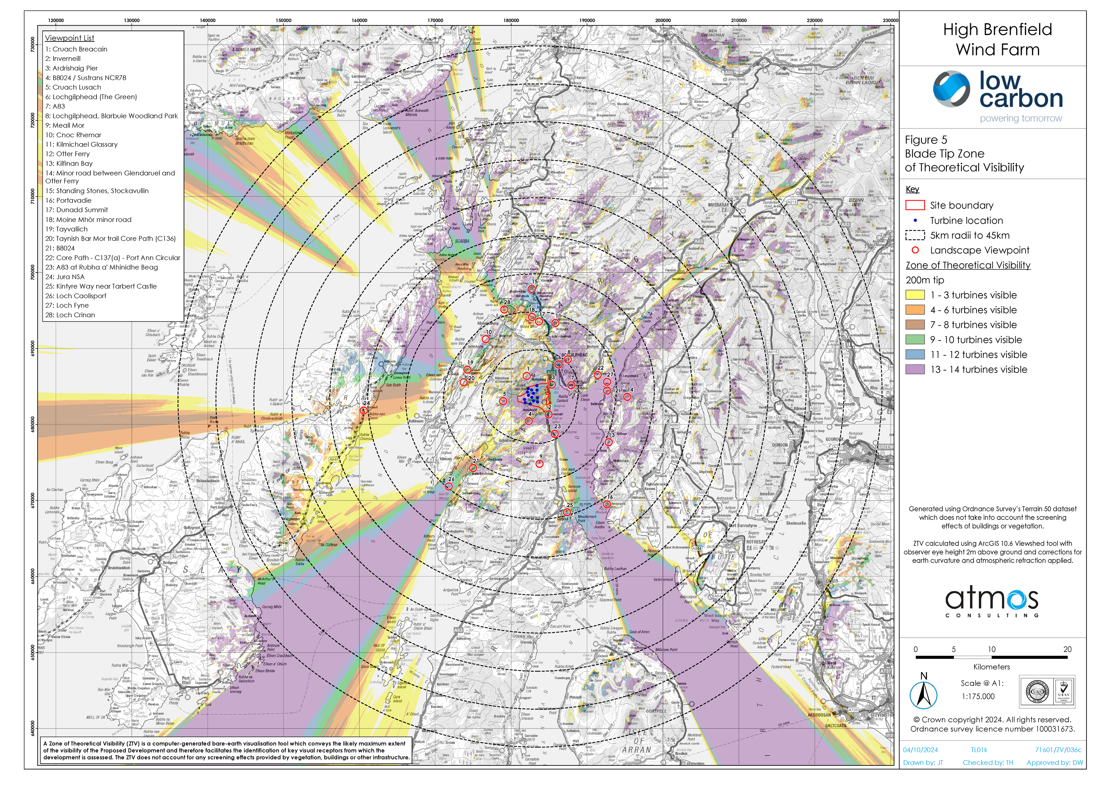
- Volume 4 - Figure 5-3 Blade Tip Zone of Theoretical Visibility to 45km with Viewpoints (A3)
- Volume 4 - Figure 5-4 Blade Tip Zone of Theoretical Visibility to 45km with Viewpoints (A1)
- Volume 4 - Figure 5-5 Blade Tip Zone of Theoretical Visibility to 20km with Viewpoints (A3)
- Volume 4 - Figure 5-6 Blade Tip Zone of Theoretical Visibility to 20km with Viewpoints (A1)
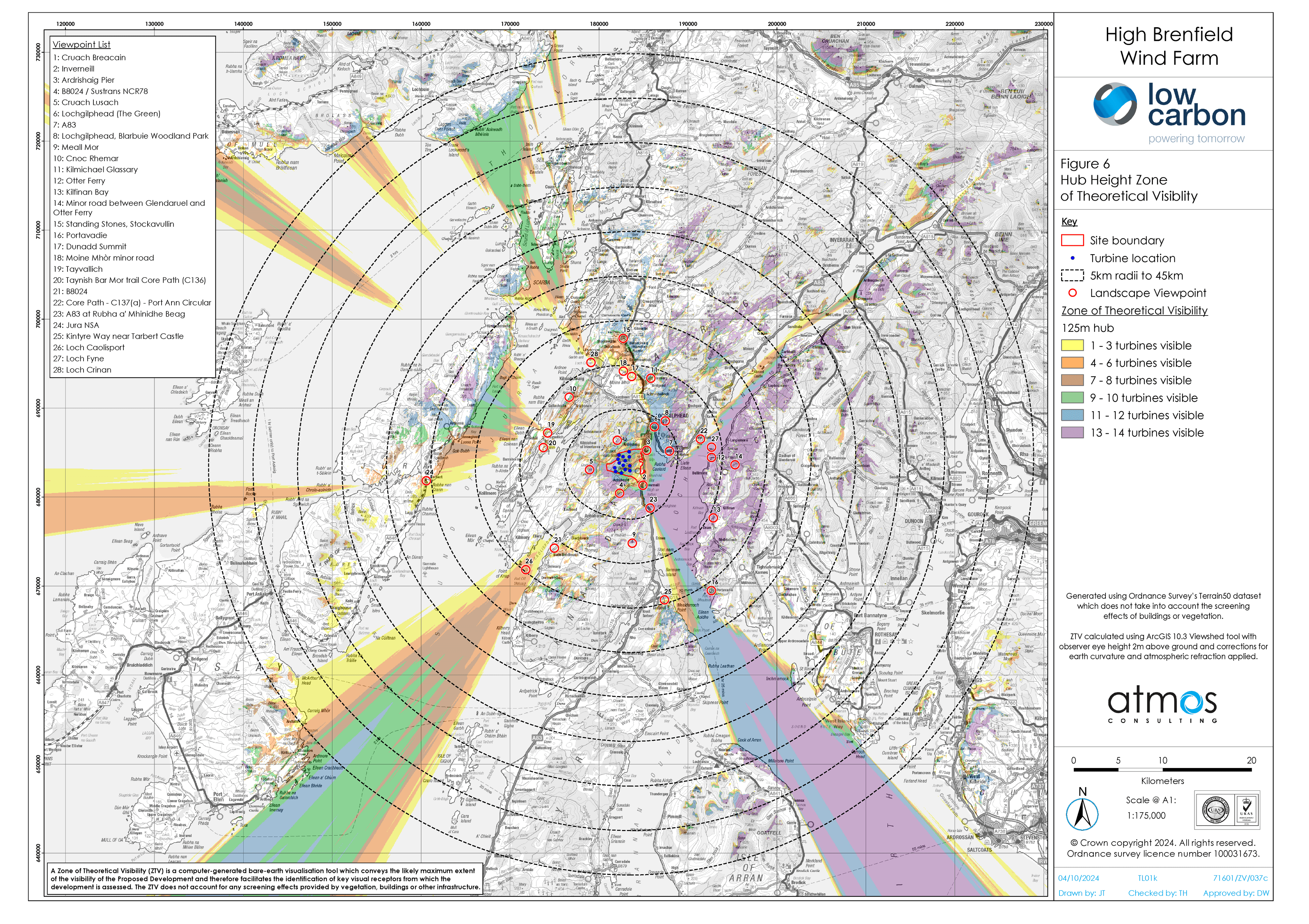
- Volume 4 - Figure 5-7 Hub Height Zone of Theoretical Visibility to 45km with Viewpoints (A3)
- Volume 4 - Figure 5-8 Hub Height Zone of Theoretical Visibility to 45km with Viewpoints (A1)
- Volume 4 - Figure 5-9 Hub Height Zone of Theoretical Visibility to 20km with Viewpoints (A3)
- Volume 4 - Figure 5-10 Hub Height Zone of Theoretical Visibility to 20km with Viewpoints (A1)
- Volume 4 - Figure 5-11 Dark Sky Baseline Satellite Image
- Volume 4 - Figure 5-12 Lit Turbine Zone of Theoretical Visibility to 20km with Viewpoints
- Volume 4 - Figure 5-13 Lit Turbine Lighting Intensity Zone of Theoretical Visibility to 20km with Viewpoints
- Volume 4 - Figure 5-14 Landscape Designations within 45km with Viewpoints
- Volume 4 - Figure 5-15 Landscape Designations to 20km with Blade Tip Zone of Theoretical Visibility and Viewpoints
- Volume 4 - Figure 5-16 Landscape Character Types within 45km with Viewpoints
- Volume 4 - Figure 5-17 Landscape Character within 20km with Blade Tip Zone of Theoretical Visibility and Viewpoints
- Volume 4 - Figure 5-18 Topography Plan to 20km
- Volume 4 - Figure 5-19 Local Landscape Context to 5km
- Volume 4 - Figure 5-20 Principal Visual Receptors to 45km with Blade Tip Zone of Theoretical Visibility Viewpoints
- Volume 4 - Figure 5-21 Principal Visual Receptors to 20km with Blade Tip Zone of Theoretical Visibility Viewpoints
- Volume 4 - Figure 5-22 Other Wind Farms within 45km
- Volume 4 - Figure 5-23 Other Wind Farms within 20km
- Volume 4 - Figure 5-24 Cumulative Zone of Theoretical Visibilty-Operational Under Construction Srondoire Allt Dearg
- Volume 4 - Figure 5-25 Cumulative Zone of Theoretical Visibility-Operational Under Construction A Chruach
- Volume 4 - Figure 5-26 Cumulative Zone of Theoretical Visibility with Consented Rowan
- Volume 4 - Figure 5-27 Cumulative Zone of Theoretical Visibility with Consented Airigh
- Volume 4 - Figure 5-28 Cumulative Zone of Theoretical Visibility with Consented Glasvaar
- Volume 4 - Figure 5-29 Viewpoint 1 - Cruach Breacain
- Volume 4 - Figure 5-30 Viewpoint 2 - Inverneill
- Volume 4 - Figure 5-31 Viewpoint 3 - Ardrishaig Pier
- Volume 4 - Figure 5-32 Viewpoint 4 - B8024 Sustrans NCR78
- Volume 4 - Figure 5-33 Viewpoint 5 - Cruach Lusach
- Volume 4 - Figure 5-34 Viewpoint 6 - Lochgilphead Conservation Area Waterfront
- Volume 4 - Figure 5-35 Viewpoint 7 - A83
- Volume 4 - Figure 5-36 Viewpoint 8 - Lochgilphead Blarbuie Woodland Park
- Volume 4 - Figure 5-37 Viewpoint 9 - Meall Mor
- Volume 4 - Figure 5-38 Viewpoint 10 - Cnoc Rhemar
- Volume 4 - Figure 5-39 Viewpoint 11 - Kilmichael Glassary
- Volume 4 - Figure 5-40 Viewpoint 12 - Otter Ferry
- Volume 4 - Figure 5-41 Viewpoint 13 - Kilfinan Bay
- Volume 4 - Figure 5-42 Viewpoint 14 - Minor road between Glendaruel and Otter Ferry
- Volume 4 - Figure 5-43 Viewpoint 15 - Standing Stones Stockavullin
- Volume 4 - Figure 5-44 Viewpoint 16 - Portavadie
- Volume 4 - Figure 5-45 Viewpoint 17 - Dunadd Summit
- Volume 4 - Figure 5-46 Viewpoint 18 - Moine Mhor minor road
- Volume 4 - Figure 5-47 Viewpoint 19 - Tayvallich
- Volume 4 - Figure 5-48 Viewpoint 20 - Taynish Barr Mor trail Core Path (C136)
- Volume 4 - Figure 5-49 Viewpoint 21 - B8024
- Volume 4 - Figure 5-50 Viewpoint 22 - Core Path - C137(a) - Port Ann Circular
- Volume 4 - Figure 5-51 Viewpoint 23 - A83 at Rubha a' Mhinidhe Beag
- Volume 4 - Figure 5-52 Viewpoint 24 - Jura NSA
- Volume 4 - Figure 5-53 Wireline 1- Kintyre Way near Tarbert Castle
- Volume 4 - Figure 5-54 Wireline 2- Loch Caolisport
- Volume 4 - Figure 5-55 Wireline 3- Loch Fyne
- Volume 4 - Figure 5-56 Wireline 4- Loch Crinan
- Volume 4 - Figures 5-7-1 to 5-7-19 Residential and Visual Amenity Assessment
- Volume 4 - Figure 6-1 Phase 1 Habitat Results
- Volume 4 - Figure 6-2 NVC Survey Results Map
- Volume 4 - Figure 6-3 Bat Static Locations
- Volume 4 - Figure 6-4 Protected Species Survey Map
- Volume 4 - Figure 6-5 Fish Habitat Survey Results Map
- Volume 4 - Figure 6-6 Statutory Designated Sites within 10km
- Volume 4 - Figure 6-7 Non-Statutory Designated Sites within 3km
- Volume 4 - Figure 6-8 Habitat Management Areas
- Volume 4 - Figure 7-1-1 Survey Areas and Knapdale Diver Lochs
- Volume 4 - Figure 7-1-2 Vantage Point Locations and Viewsheds
- Volume 4 - Figure 7-1-3 Ornithological Designations within 20km
- Volume 4 - Figure 7-1-4 Vantage Point Raptor Flightlines (April 2022 - March 2023)
- Volume 4 - Figure 7-1-5 Vantage Point Non-Raptor Flightlines (April 2022 - March 2023)
- Volume 4 - Figure 7-1-6 Vantage Point Raptor Flightlines (April 2023 - March 2024)
- Volume 4 - Figure 7-1-7 Vantage Point Non-Raptor Flightlines (April 2023 - March 2024)
- Volume 4 - Figure 7-1-8 Breeding Raptor Territories 2022
- Volume 4 - Figure 7-1-9 Breeding Raptor Territories 2023
- Volume 4 - Figure 8-1 Topography
- Volume 4 - Figure 8-1-1 Watercourse Crossings
- Volume 4 - Figure 8-1-2 Typical Watercourse Crossing Details
- Volume 4 - Figure 8-2 Designated Sites
- Volume 4 - Figure 8-2-1 Slope Angle
- Volume 4 - Figure 8-2-2 Superficial Geology
- Volume 4 - Figure 8-2-3 Bedrock Geology
- Volume 4 - Figure 8-2-4 Carbon and Peatland Map
- Volume 4 - Figure 8-2-5A Peat Depth
- Volume 4 - Figure 8-2-5B Peat Depth
- Volume 4 - Figure 8-2-5C Peat Depth
- Volume 4 - Figure 8-2-5D Peat Depth
- Volume 4 - Figure 8-2-6 Peat Depth Interpolation
- Volume 4 - Figure 8-2-7 Geomorphology
- Volume 4 - Figure 8-2-8 Factor of Safety
- Volume 4 - Figure 8-2-9A Loading Analysis
- Volume 4 - Figure 8-2-9B Loading Analysis
- Volume 4 - Figure 8-2-10 Qualitative Assessment Contributory Factors
- Volume 4 - Figure 8-2-11A Qualitative Assessment Result
- Volume 4 - Figure 8-2-11B Qualitative Assessment Result
- Volume 4 - Figure 8-2-11C Qualitative Assessment Result
- Volume 4 - Figure 8-2-12 Calculated Risk Areas
- Volume 4 - Figure 8-3 Hydrological Overview
- Volume 4 - Figure 8-3-1A Peat Depth Survey Results
- Volume 4 - Figure 8-3-1B Peat Depth Survey Results
- Volume 4 - Figure 8-3-1C Peat Depth Survey Results
- Volume 4 - Figure 8-3-1D Peat Depth Survey Results
- Volume 4 - Figure 8-3-2 Peat Depth Interpolation
- Volume 4 - Figure 8-4 Superficial Geology
- Volume 4 - Figure 8-4-1 Private Water Supply Properties
- Volume 4 - Figure 8-4-2 Private Water Supply Assessment
- Volume 4 - Figure 8-5 Bedrock Geology
- Volume 4 - Figure 8-5-1 Site Location Plan
- Volume 4 - Figure 8-5-2 Drainage Strategy Overview
- Volume 4 - Figure 8-5-3 Drainage Strategy Sheet 1
- Volume 4 - Figure 8-5-4 Drainage Strategy Sheet 2
- Volume 4 - Figure 8-5-5 Drainage Strategy Sheet 3
- Volume 4 - Figure 8-5-6 Drainage Strategy Sheet 4
- Volume 4 - Figure 8-5-7 Drainage Strategy Sheet 5
- Volume 4 - Figure 8-5-8 Typical Drainage Details
- Volume 4 - Figure 8-6 Carbon and Peatland Map
- Volume 4 - Figure 8-6-1 Proposed Borrow Pit Overview
- Volume 4 - Figure 8-6-2 Proposed Borrow Pit Design and Sections
- Volume 4 - Figure 8-7A Peat Depth Survey Results
- Volume 4 - Figure 8-7B Peat Depth Survey Results
- Volume 4 - Figure 8-7C Peat Depth Survey Results
- Volume 4 - Figure 8-7D Peat Depth Survey Results
- Volume 4 - Figure 8-8 Peat Depth Interpolation
- Volume 4 - Figure 8-9 Hydrogeology
- Volume 4 - Figure 8-10 Potential Ground Water Dependent Terrestrial Ecosystem
- Volume 4 - Figure 9-1 Transport Study Area
- Volume 4 - Figure 9-2 Traffic Counters Locations
- Volume 4 - Figure 9-3 Abnormal Loads Route
- Volume 4 - Figure 10-1 Scheduled Monuments within 15km
- Volume 4 - Figure 10-2 Listed Buildings Conservation Areas and Inventoried Gardens and Designed Landscapes
- Volume 4 - Figure 10-3 Non-Statutory Register C Non-Statutory Register V Non-Designated Assets of Potential Significance
- Volume 4 - Figure 10-4 Non-Designated Heritage Assets and Previous Archaeological Investigations within 1km of Site
- Volume 4 - Figure 10-5 Pre-Ordnance Survey Maps (1654-1824)
- Volume 4 - Figure 10-6 Ordnance Survey Map of 1873
- Volume 4 - Figure 10-7 Ordnance Survey Map of 1900
- Volume 4 - Figure 10-8 Designated Heritage Assets within the blade tip Zone of Theoretical Visibility
- Volume 4 - Figure 10-9 Cultural Heritage Viewpoint 1 - Crinan Canal
- Volume 4 - Figure 10-10 Cultural Heritage Viewpoint 2 - Achnabreck Prehistoric Rock Carvings
- Volume 4 - Figure 10-11 Cultural Heritage Viewpoint 3 - Moine Mhor & Dunadd
- Volume 4 - Figure 10-12 Cultural Heritage Viewpoint 4 - Dunadd Fort
- Volume 4 - Figure 10-13 Cultural Heritage Viewpoint 5 - Kilmartin Glen - Carncasserie Castle
- Volume 4 - Figure 10-14 Cultural Heritage Viewpoint 6 - Kilmartin Glen - Temple Wood Stone Circle
- Volume 4 - Figure 10-15 Cultural Heritage Viewpoint 7 - Kilmartin Glen - Ballymeanoch Standing Stones
- Volume 4 - Figure 10-16 Cultural Heritage Viewpoint 8 - Kilmartin Glen - Glebe Cairn
- Volume 4 - Figure 10-17 Cultural Heritage Viewpoint 9 - Otter Ferry
- Volume 4 - Figure 10-18 Cultural Heritage Viewpoint 10 - Barr Lagan
- Volume 4 - Figure 10-19 Cultural Heritage Viewpoint 11 - Barr Iola
- Volume 4 - Figure 10-20 Cultural Heritage Viewpoint 12 - Ballimore House and Garden and Designated Landscape
- Volume 4 - Figure 10-21 Cultural Heritage Viewpoint 13 - Islandadd Bridge
- Volume 4 - Figure 10-22 Cultural Heritage Viewpoint 14 - Lochgilphead Conservation Area- Waterfront
- Volume 4 - Figure 10-23 Cultural Heritage Viewpoint 15 - A83 Lochgilphead Clock Lodge
- Volume 4 - Figure 10-24 Cultural Heritage Viewpoint 16 - Duntrune Castle
- Volume 4 - Figure 10-25 Cultural Heritage Viewpoint 17 - Old Castle Lachlan, (Cowal Peninsula), Loch Fyne
- Volume 4 - Figure 10-26 Cultural Heritage Viewpoint 18 - Loch Gilp Navigation Channel
- Volume 4 - Figure 10-27 Cultural Heritage Viewpoint 19 - Auchoish Long Cairn
- Volume 4 - Figure 10-28 Cultural Heritage Viewpoint 20 - Dunadd Standing Stone
- Volume 4 - Figure 11-1 Predicted Operational Noise Contours at 10m per s
- Volume 4 - Figure 12-1 Forestry Baseline
- Volume 4 - Figure 12-2 Felling Without Wind Farm
- Volume 4 - Figure 12-3 Replanting without wind farm
- Volume 4 - Figure 12-4 Felling for wind farm
- Volume 4 - Figure 12-5 Replanting with wind farm
- Volume 4 - Figure 12-6 Attichuan Access Detail
- Volume 4 - Figure 15-1 Shadow Flicker
- Volume 4 - Figure 15-2 Aviation Constraints
- Volume 4 - Design and Access Statement- Figure 1 Site Location Plan
- Volume 4 - Figure 2 Site Layout
- Volume 4 - Figure 3 Site Context
- Volume 4 - Figure 4 Design Evolution
- Volume 4 - Design and Access Statement - Figure 5 Core Paths and National Cycle Routes
Supporting Documents
- Design and Access Statement Appendix 1 Comparative Wirelines- Viewpoint 2 Inverneill
- Design and Access Statement Appendix 1 Comparative Wirelines- Viewpoint 3 Ardrishaig Pier
- Design and Access Statement Appendix 1 Comparative Wirelines-Viewpoint 6 Lochgilphead Conservation Area Waterfront
- Design and Access Statement Appendix 1 Comparative Wirelines-Viewpoint 12 Otter Ferry
- Design and Access Statement Appendix 1 Comparative Wirelines-Viewpoint 19 Tayvallich
- Supporting Document - Planning Statement
- Supporting Documents - Design and Access Statement
- Supporting Documents - Pre-application Consultation Report
- Supporting Documents - Pre-application Consultation Report Appendix A - Public Exhibition 1 Residents Letter
- Supporting Documents - Pre-application Consultation Report- Appendix B - Public Exhibition 1 Boards and Figures
- Supporting Documents - Pre-application Consultation Report-Appendix C - Exhibition 1 Post-Event Report
- Supporting Documents - Pre-application Consultation Report-Appendix D - Public Exhibition 2 Residents Letter
- Supporting Documents - Pre-application Consultation Report-Appendix E - Public Exhibition 2 Boards and Figures
- Supporting Documents - Pre-application Consultation Report-Appendix F - Exhibition 2 Post-Event Report
- Supporting Documents - Pre-application Consultation Report-Appendix G - First and Second Public Exhibition Feedback Forms
- Supporting Documents - Pre-application Consultation Report-Appendix H - Engagement Log
- Supporting Documents - Pre-application Consultation Report-Appendix I - 2nd Public Exhibition FAQs
Latest News
A Brilliant Day of Repair, Creativity and Community Spirit
We had a brilliant day at the Community Repairs Day organised by the GRAB Trust’s ReMake Argyll project on Saturday, with fantastic energy and a real buzz throughout the hall. It truly felt like a space built around connection, learning and care towards things people owned.
From Dr Bike and garden tool sharpening to electrical and mechanical repairs and clothing alterations, there was huge enthusiasm for repairing rather than replacing. The Curiosity Corner was a great addition, with families getting hands‑on, taking apart e‑waste and discovering how everyday items work, while skills were shared freely across generations. The community café from MOMA added to the warm, welcoming atmosphere.
It was inspiring to see so many people so passionate about sustainability and community-led action. Huge thanks to GRAB Trust for hosting the event and for welcoming Low Carbon along - we loved being part of such a positive and uplifting day.
View all NewsBenefits of Low Carbon Development
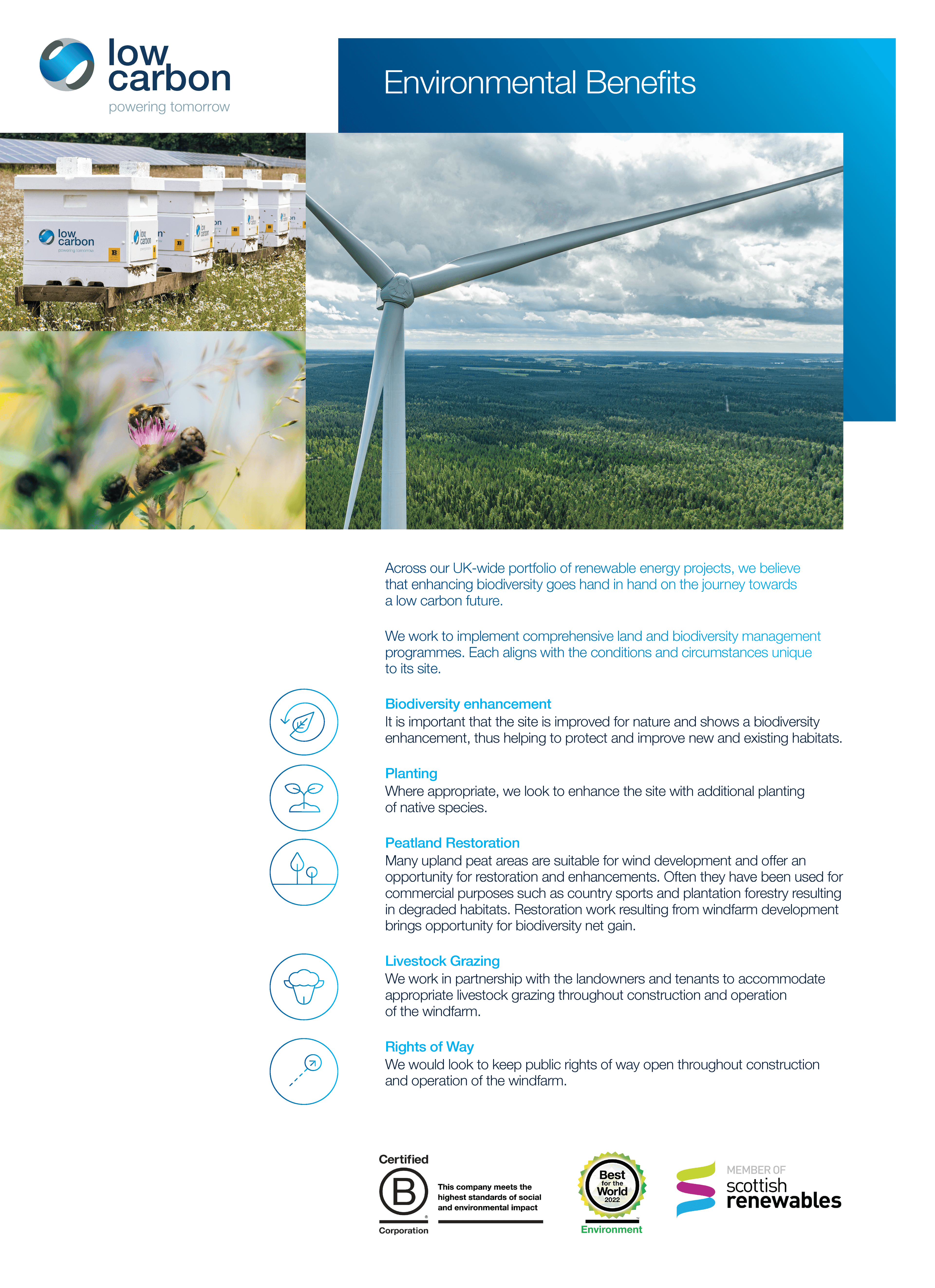
Across our portfolio of renewable energy projects, we have championed biodiversity as a critical milestone on the journey towards a low-carbon future.
Wind resource is plentiful in Scotland and can be utilised to provide security of supply and add to the renewable energy generation mix.
Biodiversity
Across our portfolio of renewable energy projects, we have championed biodiversity as a critical milestone on the journey towards a low-carbon future.
Planting
Where appropriate, we will look to enhance the site with additional planting of native species.
Livestock Grazing
We work in partnership with our landowners and tenants to accommodate appropriate livestock grazing throughout construction and operation of our wind farms.
Public Rights of Way
We intend to keep access to public rights of way open throughout construction and operation of the windfarm, subject to health and safety constraints, and will seek to improve access wherever possible.
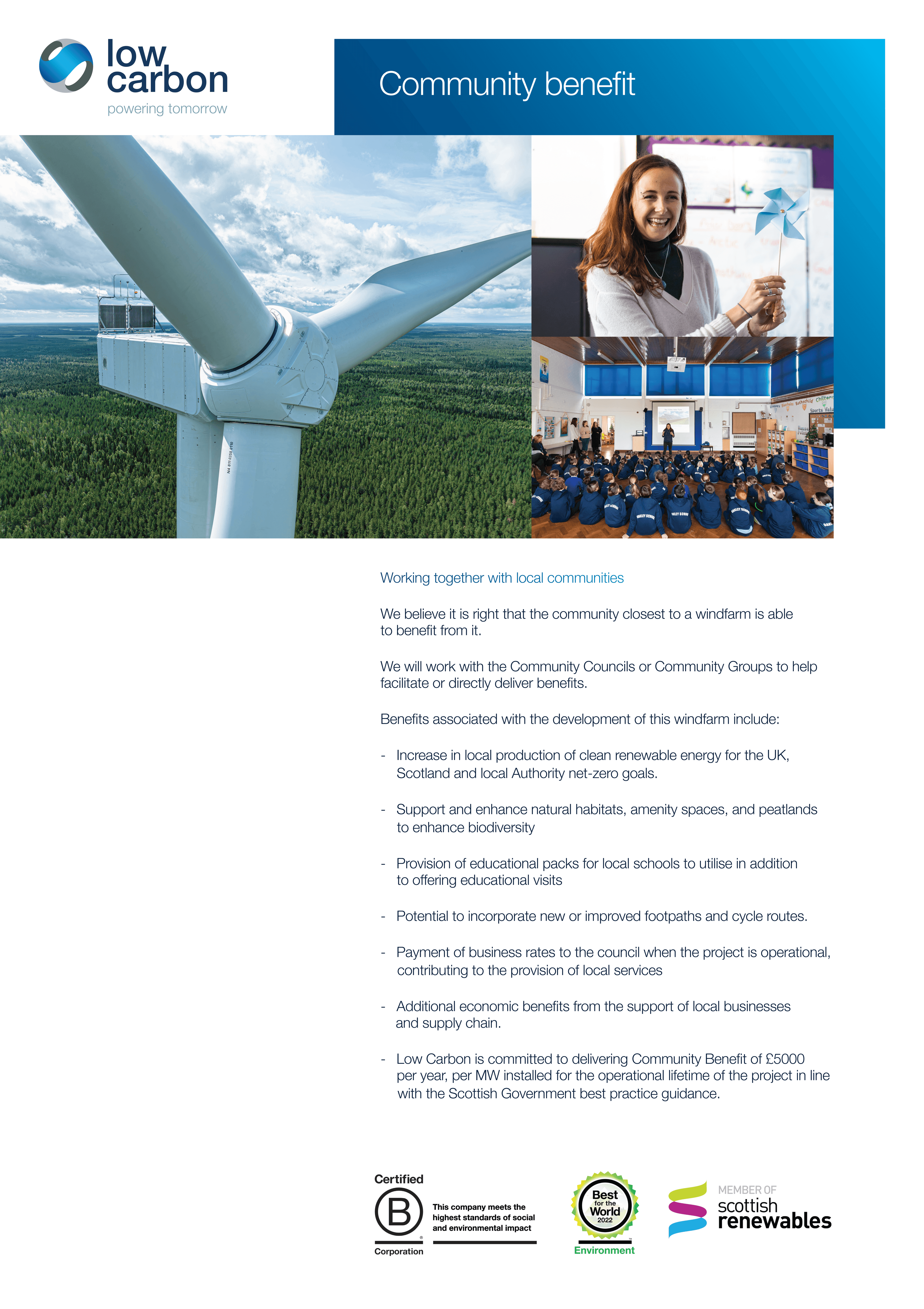
Community Benefit
Low Carbon is committed to delivering Community Benefit of £5000 per MW installed per annum (index linked) for the operational lifetime of the project in line with the Scottish Government best practice guidance.
Where there is an appetite, Low Carbon will work with communities to explore shared ownership options.
Supply Chain
A variety of suppliers are sourced throughout the development, construction, operation and decommissioning of a wind farm. Where possible, Low Carbon will seek to appoint suppliers offering local employment and/or apprenticeships.
Please contact us to note your interest.
Proposed Development
The Proposed Development comprises of up to 10 stand-alone, three bladed horizontal axis wind turbines with a maximum tip height of 200m, a permanent met mast up to 125m and associated infrastructure. The number and location of the turbines and associated infrastructure has been subject to thorough consultation and has now been finalised following a detailed iterative design process.
The Proposed Development also includes habitat restoration and enhancement measures which are further defined within the Environmental Impact Assessment.
Any predicted environmental effects arising from the Proposed Development have been addressed through embedded mitigation as far as reasonably possible. Where necessary, additional specific mitigation measures have been committed to further reduce adverse effects during the construction, operational and decommissioning phases of the development.
Low Carbon champions biodiversity as a critical milestone on the journey towards a low-carbon future and therefore has included within the Proposed Development a comprehensive land and biodiversity management programme, aligned to the unique conditions and circumstances of the site.
Further Environmental Information
In December 2025 Low Carbon submitted Further Environmental Information (FEI) in response to consultee comments from Historic Environment Scotland and Argyll and Bute Council’s Biodiversity Officer. The FEI provides additional information regarding cultural heritage, forestry, ecology, ornithology and biodiversity.
The FEI documents can be viewed using the links below.
If you would like a download link for the FEI documents emailed directly to you, please contact info@highbrenfieldwindfarm.co.uk.
All FEI documents can be viewed and downloaded via the Scottish Government Energy Consents Unit.
Public Notice - Further Environmental Information
DownloadHigh Brenfield Wind Farm FEI ECU Cover Letter
DownloadAdditional Information - Non-Technical Summary
DownloadAdditional Information - Further Environmental Information Report
DownloadAppendix A - Cultural Heritage Viewpoint 1
DownloadAppendix A - Cultural Heritage Viewpoint 2
DownloadAppendix A - Cultural Heritage Viewpoint 3
DownloadAppendix A - Cultural Heritage Viewpoint 4
DownloadAppendix B - Tree Survey Report
DownloadTree Survey Appendix A - Schedule of Trees
DownloadTree Survey Appendix B - Photographic Records
DownloadTree Survey Drawing 1 - Tree locations with proposed felling
DownloadTree Survey Drawing 2 - 12-6 Attichuan Access Detail
DownloadAppendix C - Bat Report 2025
DownloadAppendix C - Figure 1 Bat Static Locations
DownloadThe Global Climate Emergency - Scotland's Response
Climate Change Secretary Roseanna Cunningham's statement – Published 14th May 2019:
“Scotland’s response to the climate emergency must be hardwired into our national psyche. We must take this journey together, seize the economic opportunities available to us and redefine what world leadership means, not just as a government but as a country. Scotland has declared a global climate emergency and now Scotland must act as one to safeguard our planet for future generations.”
Onshore wind: policy statement 2022 – Published 21st December 2022:
“This statement, which is the culmination of an extensive consultative process with industry, our statutory consultees and the public, sets an overall ambition of 20 GW of installed onshore wind capacity in Scotland by 2030.”
Virtual Exhibitions
First Virtual Exhibition
First Virtual Exhibition
Welcome to the first Public Exhibition for our proposals at High Brenfield Wind Farm.
This information provides an overview of the Scoping proposals at High Brenfield which will be refined as further studies, site surveys and stakeholder and community engagement is undertaken.
We are holding second Public Exhibitions in October 2024, and materials from those events will be published here.
Please note: Any comments made to Low Carbon at this stage are not representations to the Scottish Ministers. If Low Carbon submits an application in relation to the Proposed Development, there will be an opportunity to make representations to Scottish Ministers during the statutory consultation period after the formal submission.
Second Virtual Exhibition
Click above to view the exhibition
Second Virtual Exhibition
Welcome to the second Public Exhibition for our proposals at High Brenfield Wind Farm. The materials presented here are consistent with what we are presenting at our in person events.
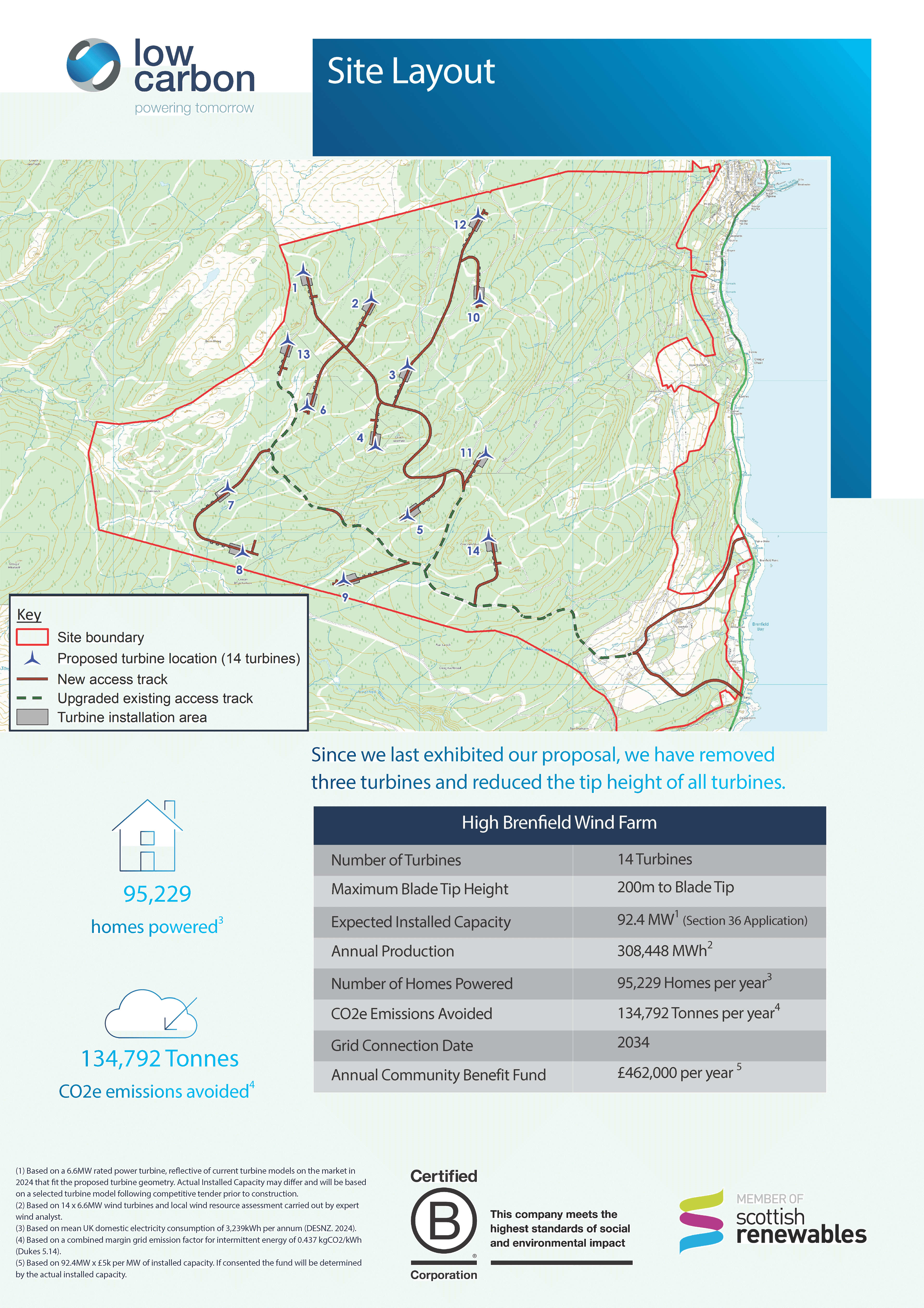
This information provides an overview of how the proposals at High Brenfield have been refined since Scoping as further studies, site surveys and stakeholder and community engagement has been undertaken. Key design modifications include removal of three turbines and a tip height reduction from 220m to 200m.
Please note: Any comments made to Low Carbon at this stage are not representations to the Scottish Ministers. If Low Carbon submits an application in relation to the Proposed Development, there will be an opportunity to make representations to Scottish Ministers during the statutory consultation period after the formal submission.
Welcome to the second Public Exhibition for our proposals at High Brenfield Wind Farm. The materials presented here are consistent with what we are presenting at our in person events.
This information provides an overview of how the proposals at High Brenfield have been refined since Scoping as further studies, site surveys and stakeholder and community engagement has been undertaken. Key design modifications include removal of three turbines and a tip height reduction from 220m to 200m.
Please note: Any comments made to Low Carbon at this stage are not representations to the Scottish Ministers. If Low Carbon submits an application in relation to the Proposed Development, there will be an opportunity to make representations to Scottish Ministers during the statutory consultation period after the formal submission.
Design Freeze Layout
Click above to view the exhibition
Design Freeze Layout
In October 2024 Low Carbon hosted public exhibitions in both Ardrishaig and Lochgilphead to gather feedback from the community regarding the High Brenfield Wind Farm proposals, which consisted of 14 turbines with a tip height of 200m. To compliment the feedback provided by the community Low Carbon sought further pre-application consultation with key statutory consultees regarding the wind farm design.
Low Carbon has considered all the feedback received from the community and consultees and has decided to remove the four turbines located closest to the settlements of Ardrishaig, Inverneill and Lochgilphead from the development (Turbines 10, 11, 12 & 14). As such, the High Brenfield Wind Farm layout which will be assessed within the EIA and submitted to the Scottish Government’s Energy Consents Unit (ECU) for determination will consist of 10 turbines at 200m tip height, with a maximum generating capacity of 66MW.
Low Carbon remains committed to delivering a community benefit fund of £5,000 per megawatt of installed capacity per year (index linked) for the wind farm’s operational lifetime, in line with Scottish Government good practice guidance. This equates to £300k per year (based on 2025) prices).
The materials presented below are consistent with our final wind farm design.
Please note: Any comments made to Low Carbon at this stage are not representations to the Scottish Ministers. If Low Carbon submits an application in relation to the Proposed Development, there will be an opportunity to make representations to Scottish Ministers during the statutory consultation period after the formal submission.
FAQs
Low Carbon is the developer of this project and we share as much information as possible during the lifetime of our projects.
Here is a selection of questions that have been asked relating to wind farm installations/builds. These will be updated throughout the project.
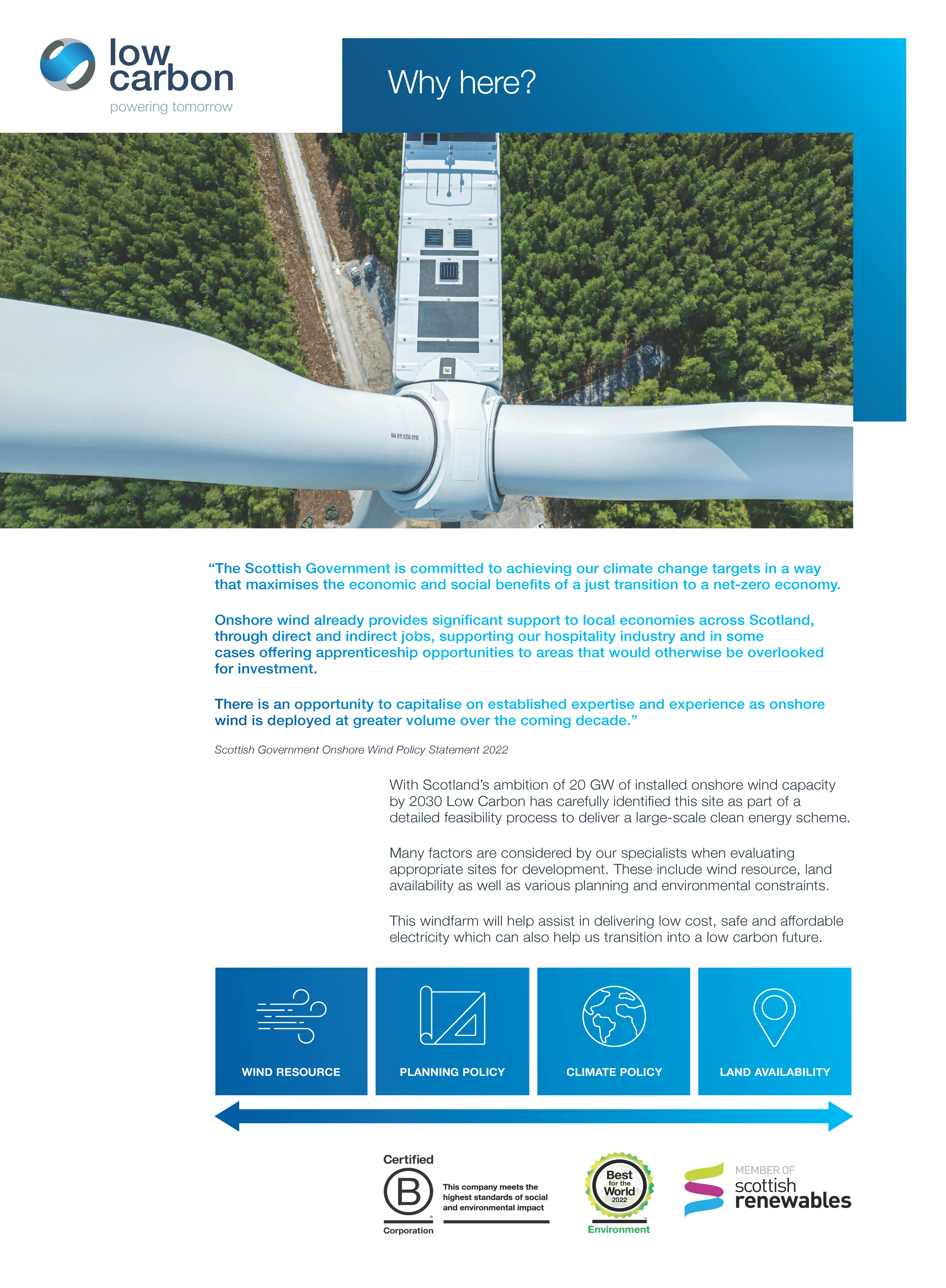
Why has Low Carbon chosen this site for High Brenfield wind farm?
Low Carbon has the target of creating 20GW of new renewable energy capacity globally. To achieve this, and to combat the effects of climate change, Low Carbon is pursuing a portfolio of wind farm development opportunities across the UK. High Brenfield is one of many locations being considered for wind farm development by Low Carbon. The proposed location has a strong wind resource, few environmental constraints, no statutory designations and is located within a commercial forestry plantation which presents an opportunity to deliver significant biodiversity enhancement.
How will visual impacts on residential properties and key visual receptors be assessed?
A Landscape and Visual Impact Assessment (LVIA) chapter is included as part of the Environmental Impact Assessment Report . The LVIA was carried out in accordance with the Landscape Institute’s Guidelines for Landscape and Visual Impact Assessment (Third Edition) and NatureScot Visual Representation of Wind Farms Guidance. Following our Scoping submission we considered feedback from the community and key consultees and have included a number of additional LVIA viewpoints as a result. The LVIA considers effects on visual receptors within the LVIA study area, including views from settlements, footpaths, cycle routes, roads and water-based receptors. Effects on residential properties within 2 km of the proposed turbines has been assessed in the Residential Visual Amenity Assessment (RVAA) which is included in an appendix to the LVIA chapter. Since sharing our Scoping layout, we have reduced the number of turbines (from 17 to 10) and the tip height of the development (from 220m to 200m) which has significantly reduced the visual impact on the settlements of Ardrishaig, Lochgilphead and Inverneill.
How will impacts on residential properties closest to the development be assessed?
Residential visual amenity was assessed in accordance with the Landscape Institute’s Technical Guidance Note on Residential Visual Amenity Assessment (RVAA). The RVAA considers the potential visual effects on all properties within 2km of the proposed turbines. Where deemed necessary and appropriate we have visited specific properties to understand the potential effects on that, and surrounding properties.
Will High Brenfield Wind Farm turbines measure 220m to blade tip?
The design iteration process for the project has been continuing since the Environmental Impact Assessment Scoping Request was submitted in November 2023 and the scheme now comprises up 10 turbines with a maximum tip height of 200 metres.
This is a reduction in both the quantity of turbines and the tip height when compared with the Scoping scheme of 17 turbines at 220 metres to blade tip.
Will the proposed High Brenfield turbines be taller than any wind turbines currently operational in the UK?
No. There are numerous consented, in-construction and operational UK wind farms which feature turbines with tip heights of 200m and more. For example, Kype Muir Extension in South Lanarkshire is operational with 8 turbines at 200m tip height, as is Longhill Burn Wind Farm in West Lothian.
Will the wind farm generate noise when it’s operational?
All operational wind farms generate noise, however based on the current layout design and candidate turbine, the relevant ETSU-R-97 noise limits will not be breached at any residential property. Meeting the relevant noise limits doesn’t mean that operational noise will not be audible, but it does ensure that the levels are considered to be acceptable.
Can infrasound generated by the wind farm impact human health?
Audible operational noise from operational wind farms is fully assessed as part of the Environmental Impact Assessment Report (EIAR).
Audible operational noise is controlled via the noise limits imposed by ETSU-R-97.
How will construction noise be considered and controlled?
Construction noise is assessed in the Environmental Impact Assessment and will be controlled via planning conditions and the local authority Environmental Health department. There will be a commitment to meet the relevant noise limits set out in BS 5228-1:2009+A1:2014 Code of Practice for Noise and Vibration Control on Construction and Open Sites. Noise will also be considered within the Construction Environmental Management Plan (CEMP) which will be prepared prior to construction commencing. The CEMP will contain details of how the relevant noise limits will be met during the construction phase.
Will our drinking water be affected by the proposed Wind Farm’s proximity to the Private Water Supplies?
We have consulted Scottish Water throughout the Environmental Impact Assessment process regarding the design of the wind farm to ensure that any potential water quality effects are appropriately mitigated. Through the design process we have removed one turbine, one crane hardstanding and 400m of track from the Kilduskland Drinking Water Protection Area (DWPA), when compared with our previous layout iteration. A bespoke, enhanced drainage strategy has been developed for construction works within the DWPA with protection of the catchment considered to be a hard constraint to the Proposed Development. Scottish Water has published Guidance for development of infrastructure within DWPA’s which has formed the minimum standards of our drainage design.
A targeted Private Water Supplies Risk Assessment was undertaken which reviewed in detail every known Private Water Supply within the development area. The Outline CEMP, produced as part of the Environmental Impact Assessment, sets out in detail the commitments, safeguards and precautions to minimise potential pollution risk from the development during the construction phase.
A bespoke drainage strategy has been developed for the site in accordance with industry standard guidance which covers potential hydrological / pollution impacts to the lnverneil Burn Site of Special Scientific Interest (SSSI) and the Kilduskland Reservoir DWPA.
Will shadow flicker be experienced within the vicinity of the development?
Shadow Flicker effects are usually only experienced under very specific climatic conditions, however shadow flicker was fully assessed within the Environmental Impact Assessment Report. The Scottish Government’s ‘Onshore wind turbines: planning advice’ and industry standard guidance states that shadow flicker effects may be experienced within a distance equal to 10x rotor diameter from the turbine. Therefore in the case of High Brenfield Wind Farm the Environmental Impact Assessment shadow flicker study area will be 1,620m, which excludes most residential properties and Ardrishaig Primary School.
Will the wind farm have a detrimental impact on the surrounding environment?
We have completed a thorough program of baseline environmental surveys and have assessed any impacts resulting from the development within the Environmental Impact Assessment Report. The site is currently operated as a commercial coniferous forestry plantation, which is of low ecological value in terms of biodiversity. Therefore, Low Carbon believes that High Brenfield Wind Farm presents an opportunity to significantly enhance biodiversity across the site through native tree planting and forest to bog restoration.
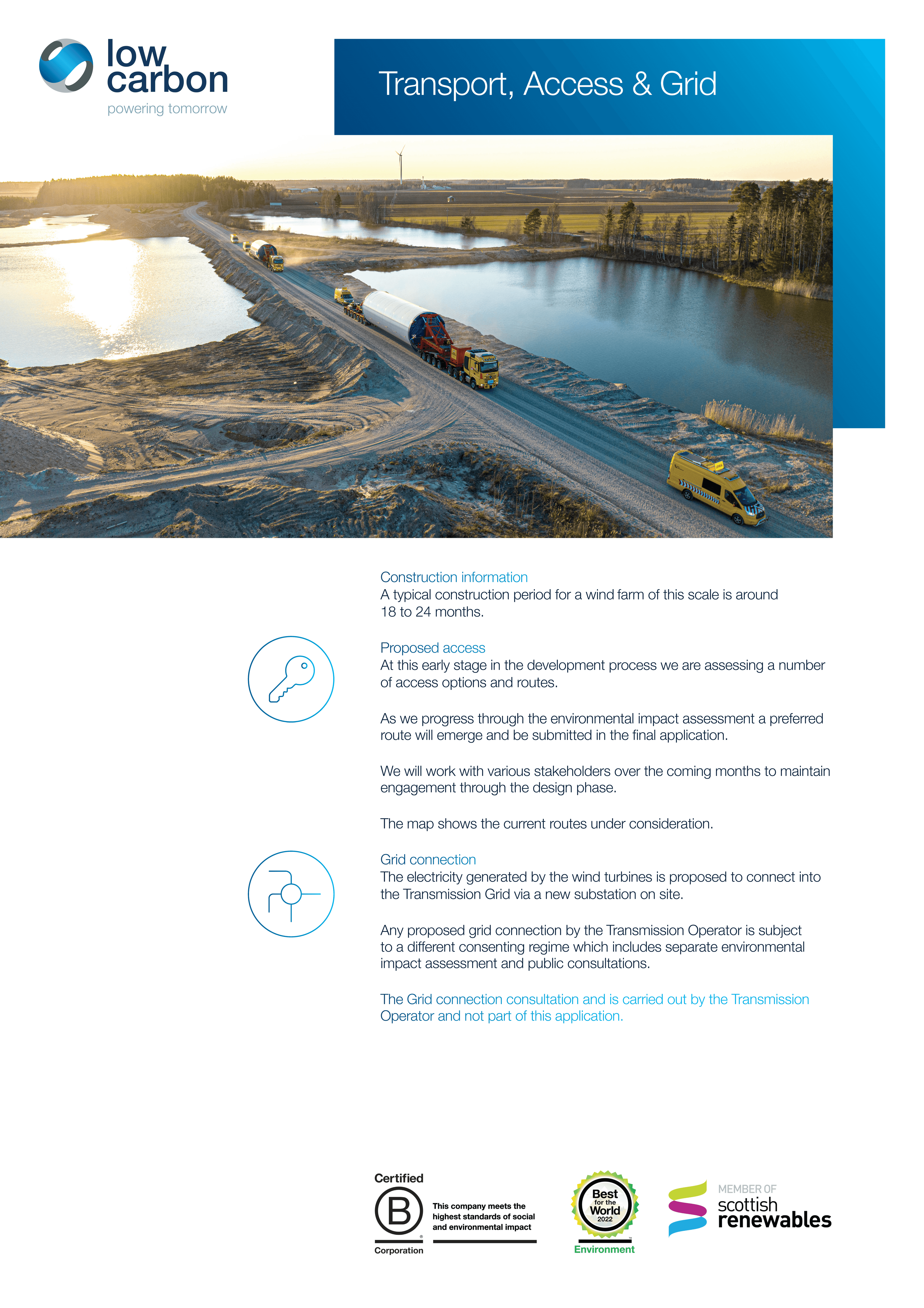
How will construction traffic and turbine deliveries access the High Brenfield Wind Farm site and will it cause further landslides in the area?
The government, local authority and police manage the impacts on roads. Low Carbon will be subject to their guidance and management and will provide assessment in the Transport chapter of the Environmental Impact Assessment report.
We anticipate turbines being delivered by sea into Campbeltown Harbour, before travelling north along the A83 to the site access location. It is expected that turbine deliveries and construction traffic will access the wind farm site via a new/upgraded existing access track which will adjoin the A83 south of Ardrishaig and north of Inverneill. Please see the updated Transportation Route figure above.
Low Carbon will seek to minimise the level of traffic generated by the development through measures such as maximising the use of on-site borrow pits to reduce the amount of stone that is brought to site by road and these details will be contained in the Traffic Management Plan (TMP). The Proposed Development will temporarily generate additional traffic during the construction period which will be assessed in the Environmental Impact Assessment Report.
Will wind farm traffic cause further landslides in the area?
The instances of landslides on both the A83 and the A816 to the north of Lochgilphead are directly linked to weather events, and whilst unfortunate for all who are impacted, the responsibility for management and maintenance of these roads lies with Transport Scotland and Argyll and Bute Council respectively. The wind farm related traffic will not cause further landslides.
Will batteries feature as part of this planning application, and if so, what is being done to mitigate the risk of fire?
Batteries do not feature within the High Brenfield Wind Farm Section 36 submission.
Has the site been chosen due to its proximity to the transmission line?
The presence of the 275kV transmission line which transects the eastern side of the proposed development site from north to south has no material benefit to the project and is not a factor in the site’s suitability for wind farm development.
Where will the project connect to the electricity grid?
A distribution grid connection application has been submitted to the distribution network operator and a connection offer has been accepted for the Proposed Development.
We are able to confirm that the development will connect into the new Craig Murrail substation located north of Lochgilphead.
When will the wind farm be connected to the grid?
A distribution grid connection offer has been accepted for the Proposed Development with a connection date of 2034, however we are hopeful that this date can be improved as a result of the Clean Power 30 grid connections reform.
Will the wind farm impact property prices?
Industry research has been conducted in relation to the impact of wind farms on residential property values. Research commissioned by the Scottish Government and led by ClimateXChange concluded that there was no “consistent evidence of a negative impact of wind turbines on house price growth”. Further research has been conducted into this matter and findings are presented within the Socio-economic, Tourism and Recreation (SeTR) assessment within the Environmental Impact Assessment Report.
Will the wind farm impact tourism?
There is no evidence that wind farms adversely affect tourism.
A research study conducted by BiGGAR Economics in 2021: Wind Farms & Tourism Trends in Scotland: Evidence from 44 Wind Farms collated evidence in order to establish whether there was a link between wind farm development and tourism trends.
The study concluded that there is no evidence of a link between wind farm development and trends in tourism, and in many cases the tourism industry grew at the same time as wind farm development activity increased.
What are the timescales for this proposed development?
Low Carbon submitted a Section 36 application for High Brenfield Wind Farm in June 2025.
How much will the Community Benefit be and how will it be distributed to the Ardrishaig community and local area?
Low Carbon are committed to supporting the communities that neighbour our wind farms and commits to delivering £5,000 per megawatt of installed capacity per year (index linked) for the wind farm’s operational lifetime, in line with Scottish Government good practice guidance.
At this early stage in the development process it is important to stress that no decision has been made about how the funds from High Brenfield Wind Farm will be administered and distributed. This decision will only be taken after an extended period of consultation with the communities that neighbour the wind farm. Consultation with a wide range of stakeholders is a cornerstone of both Low Carbon’s approach, and the Scottish Government’s good practice principles in delivering benefits from wind farms.
If approved, High Brenfield Wind Farm will provide direct benefits to the local area through a long-term community benefit fund which also opens up opportunities to develop and deliver green skills and jobs in the local area. The project team would expect to explore opportunities for investment in skills development and utilisation of the local supply chain to maximise the positive economic impact locally.
Will you offer community shared ownership?
Low Carbon is committed to offering shared community ownership in line with Scottish Government Best Practice and it is our intention to work with community groups to explore community shared ownership opportunities. We have issued a Memorandum of Understanding (MoU) to a collaborative investment group made up of community organisations located within the host and neighbouring community council areas.
Funding, advice and support is available for communities considering shared ownership, and we would encourage any interested parties to visit the Local Energy Scotland website for more information.
Will my TV signal be impacted?
The potential for adverse effects on domestic television reception is greatly diminished post digital switchover, which completed across the UK in 2012 and therefore the likelihood of significant effects is minimal. In the unlikely event that properties in this area experienced adverse effects on terrestrial TV reception, alternative signals are available from the Bellanoch and Torosay transmitters, to the north, which would be unaffected by the wind farm.
Will the site be accessible to the public?
We are eager to explore ideas with Ardrishaig Community Council regarding opportunities for enhanced public access and recreational facilities. We will work with the Argyll and Bute Council’s Access Officer to ensure the relevant access right are maintained.
Will you be planting trees?
As part of the Environmental Impact Assessment Low Carbon will be required to The Proposed Development is located within a commercial forestry plantation and it is anticipated that the site will remain a commercial forestry plantation throughout the operational life of the wind farm. Trees will need to be felled in order to facilitate construction of the wind farm infrastructure, however any felling will be compensated with tree planting either on or off site. Low Carbon has surveyed areas of land with landholdings adjacent to the site through which access to the site will be facilitated, in addition to an area of land located near Lochgilphead Golf Club, to assess their suitability for tree planting.
Does Low Carbon get paid to switch off the wind farm?
There may be occasions in which the level of electricity generation significantly exceeds the rate of electricity consumption. In these instances it is possible that the wind farm is curtailed in order to balance the electricity grid and avoid outages. When the wind farm is curtailed, and therefore unable to export electricity onto the grid, the developer is reimbursed for lost revenue.
How does energy generated by onshore wind farms benefit Scotland?
Onshore wind is one of the cheapest sources of electricity in the UK. Cheaper to produce than gas, nuclear, coal and other renewable technologies. Wind resource is plentiful in Scotland and can be utilised to provide security of supply and add to the renewable energy generation mix. The production of onshore wind energy assists the Scottish Government in achieving their carbon reduction targets, delivers significant economic benefit to communities in the form of community benefit and community shared ownership, as well as creating jobs, supply chain opportunities and significant business rates.
When will the Environmental Impact Assessment Report (EIAR) be available for review?
The Environmental Impact Assessment Report is now available on the Scottish Government’s Energy Consents Unit website at Scottish Government - Energy Consents Unit - Application Details. This will be available publicly when Low Carbon submit the Section 36 application.
How do I comment on the proposal?
A Section 36 application has been submitted to the Scottish Ministers, representations can be made via the Energy Consents Unit online portal.
At this stage, Low Carbon would encourage everyone with a view on the proposals to participate in the consultation process. Representations can be made to Scottish Ministers via the Scottish Government Energy Consents Unit, by email to representations@gov.scot; or by post to Scottish Government Energy Consents Unit, 4th Floor, 5 Atlantic Quay, 150 Broomielaw, Glasgow, G2 8LU, identifying the proposal and specifying the grounds for representation.
The consultation window is due to close on Monday 21st July 2025.
Feedback and Contacting Us
We want to ensure the community local to the Proposed Development is fully informed regarding the plans for the project. We have encouraged feedback and suggestions to help influence the design of the wind farm throughout the development process. Our project website has provided a simple and transparent way for the community to provide feedback.
The full project application is now live, including an Environmental Impact Assessment (EIA) and supporting documents, which can be viewed on our application website or on the Scottish Government’s Energy Consents website at www.energyconsents.scot under application reference ECU00004961.
At this stage, Low Carbon would encourage everyone with a view on the proposals to participate in the consultation process. Representations can be made to Scottish Ministers via the Scottish Government Energy Consents Unit, by email to representations@gov.scot; or by post to Scottish Government Energy Consents Unit, 4th Floor, 5 Atlantic Quay, 150 Broomielaw, Glasgow, G2 8LU, identifying the proposal and specifying the grounds for representation. The consultation window is due to close on Monday 21st July 2025.
Supply Chain Register
If you are interested in supply chain opportunities with us, please complete the form below.